You are here: Home > Network List > CI - Caltech Regional Seismic Network Stations List
> Station SLA SLA, Trona, CA, USA > Earthquake Result Viewer
SLA SLA, Trona, CA, USA - Earthquake Result Viewer
| Earthquake location: |
Fiji Islands Region |
| Earthquake latitude/longitude: |
-21.1/-176.6 |
| Earthquake time(UTC): |
2003/07/27 (208) 02:04:11 GMT |
| Earthquake Depth: |
213 km |
| Earthquake Magnitude: |
5.9 MB, 6.6 MW, 6.6 MW |
| Earthquake Catalog/Contributor: |
WHDF/NEIC |
|
| Network: |
CI Caltech Regional Seismic Network |
| Station: |
SLA SLA, Trona, CA, USA |
| Lat/Lon: |
35.89 N/117.28 W |
| Elevation: |
1174 m |
|
| Distance: |
79.7 deg |
| Az: |
45.202 deg |
| Baz: |
234.698 deg |
| Ray Param: |
0.048231542 |
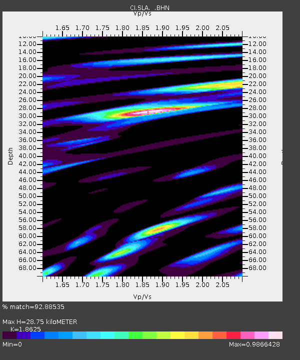
| Estimated Moho Depth: |
28.75 km |
| Estimated Crust Vp/Vs: |
1.86 |
| Assumed Crust Vp: |
6.276 km/s |
| Estimated Crust Vs: |
3.37 km/s |
| Estimated Crust Poisson's Ratio: |
0.30 |
|
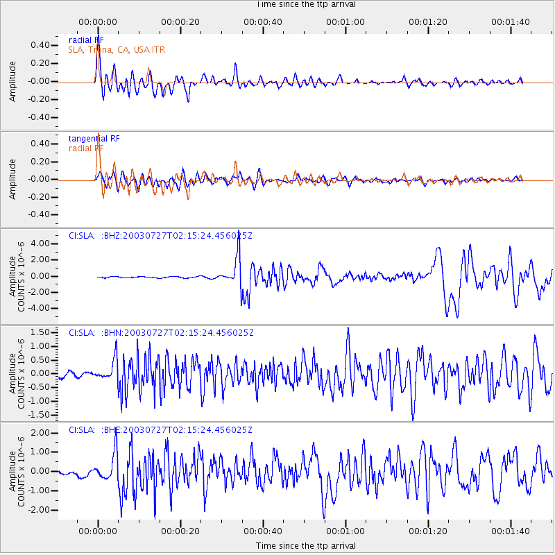
| Radial Match: |
92.88535 % |
| Radial Bump: |
400 |
| Transverse Match: |
88.43251 % |
| Transverse Bump: |
400 |
| SOD ConfigId: |
3787 |
| Insert Time: |
2010-02-25 20:30:11.561 +0000 |
| GWidth: |
2.5 |
| Max Bumps: |
400 |
| Tol: |
0.001 |
|
Signal To Noise
| Channel | StoN | STA | LTA |
| CI:SLA: :BHN:20030727T02:15:24.456025Z | 4.428724 | 3.9764853E-7 | 8.978852E-8 |
| CI:SLA: :BHE:20030727T02:15:24.456025Z | 4.3885627 | 7.2273775E-7 | 1.6468667E-7 |
| CI:SLA: :BHZ:20030727T02:15:24.456025Z | 22.945549 | 1.8768662E-6 | 8.179653E-8 |
| Arrivals |
| Ps | 4.1 SECOND |
| PpPs | 13 SECOND |
| PsPs/PpSs | 17 SECOND |


