You are here: Home > Network List > IU - Global Seismograph Network (GSN - IRIS/USGS) Stations List
> Station KONO Kongsberg, Norway > Earthquake Result Viewer
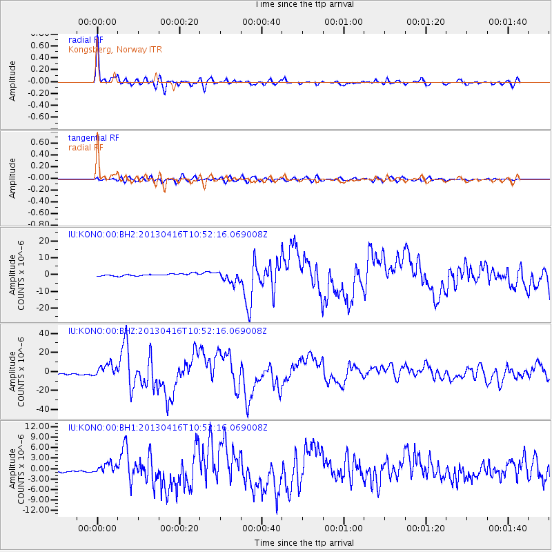
KONO Kongsberg, Norway - Earthquake Result Viewer

| Earthquake location: |
Southern Iran |
| Earthquake latitude/longitude: |
28.0/62.0 |
| Earthquake time(UTC): |
2013/04/16 (106) 10:44:20 GMT |
| Earthquake Depth: |
80 km |
| Earthquake Magnitude: |
7.7 MW, 7.0 MB, 7.7 MW |
| Earthquake Catalog/Contributor: |
NEIC PDE/NEIC PDE-W |
|
| Network: |
IU Global Seismograph Network (GSN - IRIS/USGS) |
| Station: |
KONO Kongsberg, Norway |
| Lat/Lon: |
59.65 N/9.60 E |
| Elevation: |
216 m |
|
| Distance: |
47.4 deg |
| Az: |
326.878 deg |
| Baz: |
107.976 deg |
| Ray Param: |
0.06975667 |
| Estimated Moho Depth: |
26.5 km |
| Estimated Crust Vp/Vs: |
2.09 |
| Assumed Crust Vp: |
6.545 km/s |
| Estimated Crust Vs: |
3.128 km/s |
| Estimated Crust Poisson's Ratio: |
0.35 |
|
| Radial Match: |
94.872894 % |
| Radial Bump: |
374 |
| Transverse Match: |
68.05011 % |
| Transverse Bump: |
400 |
| SOD ConfigId: |
512894 |
| Insert Time: |
2013-09-13 07:23:32.706 +0000 |
| GWidth: |
2.5 |
| Max Bumps: |
400 |
| Tol: |
0.001 |
|
Signal To Noise
| Channel | StoN | STA | LTA |
| IU:KONO:00:BHZ:20130416T10:52:16.069008Z | 7.9052873 | 6.7424976E-6 | 8.529098E-7 |
| IU:KONO:00:BH1:20130416T10:52:16.069008Z | 3.9298828 | 1.404504E-6 | 3.573908E-7 |
| IU:KONO:00:BH2:20130416T10:52:16.069008Z | 5.732134 | 3.6102128E-6 | 6.298201E-7 |
| Arrivals |
| Ps | 4.7 SECOND |
| PpPs | 12 SECOND |
| PsPs/PpSs | 17 SECOND |


