You are here: Home > Network List > IU - Global Seismograph Network (GSN - IRIS/USGS) Stations List
> Station NWAO Narrogin, Australia > Earthquake Result Viewer
NWAO Narrogin, Australia - Earthquake Result Viewer
| Earthquake location: |
Southern Iran |
| Earthquake latitude/longitude: |
28.0/62.0 |
| Earthquake time(UTC): |
2013/04/16 (106) 10:44:20 GMT |
| Earthquake Depth: |
80 km |
| Earthquake Magnitude: |
7.7 MW, 7.0 MB, 7.7 MW |
| Earthquake Catalog/Contributor: |
NEIC PDE/NEIC PDE-W |
|
| Network: |
IU Global Seismograph Network (GSN - IRIS/USGS) |
| Station: |
NWAO Narrogin, Australia |
| Lat/Lon: |
32.93 S/117.24 E |
| Elevation: |
380 m |
|
| Distance: |
80.2 deg |
| Az: |
135.47 deg |
| Baz: |
312.515 deg |
| Ray Param: |
0.048298787 |
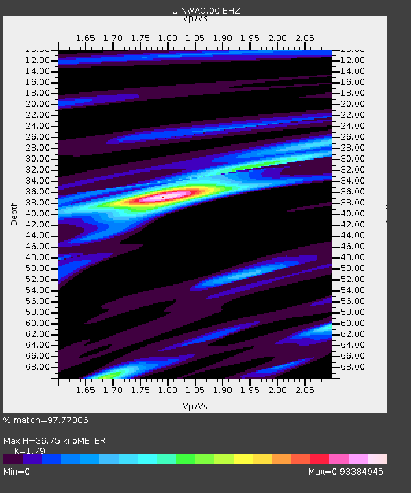
| Estimated Moho Depth: |
36.75 km |
| Estimated Crust Vp/Vs: |
1.79 |
| Assumed Crust Vp: |
6.419 km/s |
| Estimated Crust Vs: |
3.586 km/s |
| Estimated Crust Poisson's Ratio: |
0.27 |
|
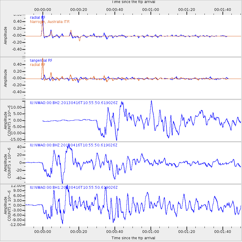
| Radial Match: |
97.77006 % |
| Radial Bump: |
323 |
| Transverse Match: |
86.9269 % |
| Transverse Bump: |
400 |
| SOD ConfigId: |
512894 |
| Insert Time: |
2013-09-13 07:23:53.154 +0000 |
| GWidth: |
2.5 |
| Max Bumps: |
400 |
| Tol: |
0.001 |
|
Signal To Noise
| Channel | StoN | STA | LTA |
| IU:NWAO:00:BHZ:20130416T10:55:50.619026Z | 32.01573 | 2.3260085E-5 | 7.2652045E-7 |
| IU:NWAO:00:BH1:20130416T10:55:50.619026Z | 14.503711 | 5.008351E-6 | 3.4531513E-7 |
| IU:NWAO:00:BH2:20130416T10:55:50.619026Z | 19.822405 | 8.0791115E-6 | 4.0757473E-7 |
| Arrivals |
| Ps | 4.6 SECOND |
| PpPs | 16 SECOND |
| PsPs/PpSs | 20 SECOND |


