You are here: Home > Network List > IU - Global Seismograph Network (GSN - IRIS/USGS) Stations List
> Station PMG Port Moresby, New Guinea > Earthquake Result Viewer
PMG Port Moresby, New Guinea - Earthquake Result Viewer
| Earthquake location: |
Southern Iran |
| Earthquake latitude/longitude: |
28.0/62.0 |
| Earthquake time(UTC): |
2013/04/16 (106) 10:44:20 GMT |
| Earthquake Depth: |
80 km |
| Earthquake Magnitude: |
7.7 MW, 7.0 MB, 7.7 MW |
| Earthquake Catalog/Contributor: |
NEIC PDE/NEIC PDE-W |
|
| Network: |
IU Global Seismograph Network (GSN - IRIS/USGS) |
| Station: |
PMG Port Moresby, New Guinea |
| Lat/Lon: |
9.40 S/147.16 E |
| Elevation: |
90 m |
|
| Distance: |
90.1 deg |
| Az: |
100.51 deg |
| Baz: |
298.257 deg |
| Ray Param: |
0.04168016 |
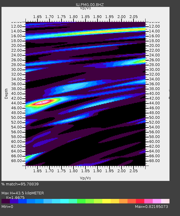
| Estimated Moho Depth: |
43.5 km |
| Estimated Crust Vp/Vs: |
1.67 |
| Assumed Crust Vp: |
6.122 km/s |
| Estimated Crust Vs: |
3.671 km/s |
| Estimated Crust Poisson's Ratio: |
0.22 |
|
| Radial Match: |
95.78839 % |
| Radial Bump: |
309 |
| Transverse Match: |
91.59606 % |
| Transverse Bump: |
400 |
| SOD ConfigId: |
512894 |
| Insert Time: |
2013-09-13 07:24:04.947 +0000 |
| GWidth: |
2.5 |
| Max Bumps: |
400 |
| Tol: |
0.001 |
|
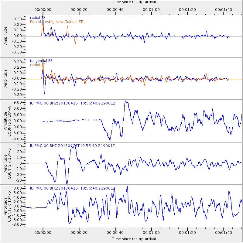
Signal To Noise
| Channel | StoN | STA | LTA |
| IU:PMG:00:BHZ:20130416T10:56:40.219001Z | 16.54378 | 1.012366E-5 | 6.119315E-7 |
| IU:PMG:00:BH1:20130416T10:56:40.219001Z | 8.210494 | 1.5646881E-6 | 1.9057173E-7 |
| IU:PMG:00:BH2:20130416T10:56:40.219001Z | 6.6269965 | 2.2248842E-6 | 3.3573036E-7 |
| Arrivals |
| Ps | 4.8 SECOND |
| PpPs | 19 SECOND |
| PsPs/PpSs | 23 SECOND |


