You are here: Home > Network List > NI - North-East Italy Broadband Network Stations List
> Station SABO Mt. Sabotino > Earthquake Result Viewer
SABO Mt. Sabotino - Earthquake Result Viewer
| Earthquake location: |
Southern Iran |
| Earthquake latitude/longitude: |
28.0/62.0 |
| Earthquake time(UTC): |
2013/04/16 (106) 10:44:20 GMT |
| Earthquake Depth: |
80 km |
| Earthquake Magnitude: |
7.7 MW, 7.0 MB, 7.7 MW |
| Earthquake Catalog/Contributor: |
NEIC PDE/NEIC PDE-W |
|
| Network: |
NI North-East Italy Broadband Network |
| Station: |
SABO Mt. Sabotino |
| Lat/Lon: |
45.99 N/13.63 E |
| Elevation: |
621 m |
|
| Distance: |
41.9 deg |
| Az: |
308.676 deg |
| Baz: |
98.188 deg |
| Ray Param: |
0.07326014 |
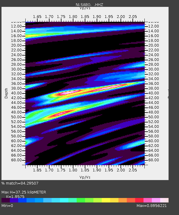
| Estimated Moho Depth: |
37.25 km |
| Estimated Crust Vp/Vs: |
1.96 |
| Assumed Crust Vp: |
6.207 km/s |
| Estimated Crust Vs: |
3.171 km/s |
| Estimated Crust Poisson's Ratio: |
0.32 |
|
| Radial Match: |
84.29507 % |
| Radial Bump: |
400 |
| Transverse Match: |
80.49351 % |
| Transverse Bump: |
400 |
| SOD ConfigId: |
512894 |
| Insert Time: |
2013-09-13 07:26:17.797 +0000 |
| GWidth: |
2.5 |
| Max Bumps: |
400 |
| Tol: |
0.001 |
|

Signal To Noise
| Channel | StoN | STA | LTA |
| NI:SABO: :HHZ:20130416T10:51:32.048011Z | 9.38553 | 7.1004933E-6 | 7.5653617E-7 |
| NI:SABO: :HHN:20130416T10:51:32.048011Z | 6.432112 | 1.5350786E-6 | 2.3865854E-7 |
| NI:SABO: :HHE:20130416T10:51:32.048011Z | 5.5127544 | 2.8534737E-6 | 5.1761305E-7 |
| Arrivals |
| Ps | 6.1 SECOND |
| PpPs | 17 SECOND |
| PsPs/PpSs | 23 SECOND |


