You are here: Home > Network List > NI - North-East Italy Broadband Network Stations List
> Station ZOU2 Zouf Plan > Earthquake Result Viewer
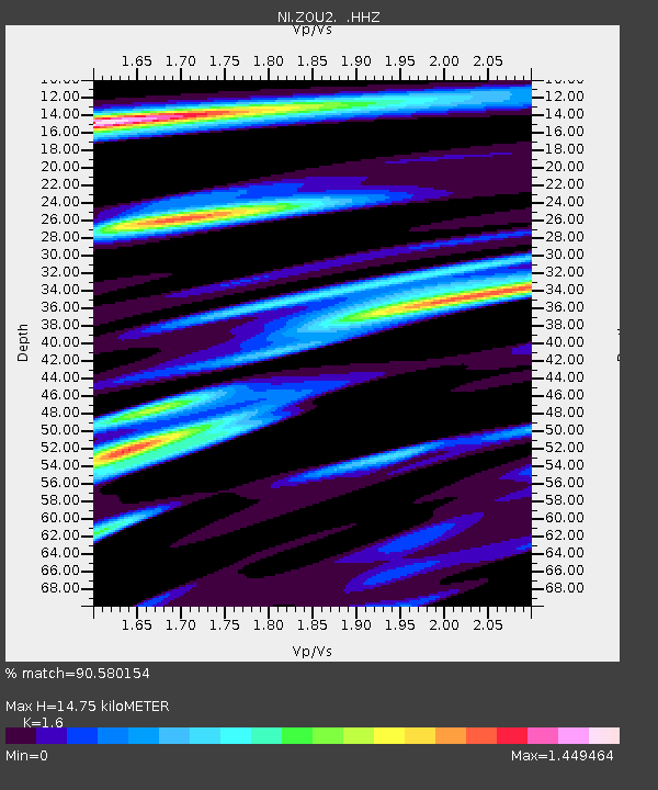
ZOU2 Zouf Plan - Earthquake Result Viewer
| Earthquake location: |
Southern Iran |
| Earthquake latitude/longitude: |
28.0/62.0 |
| Earthquake time(UTC): |
2013/04/16 (106) 10:44:20 GMT |
| Earthquake Depth: |
80 km |
| Earthquake Magnitude: |
7.7 MW, 7.0 MB, 7.7 MW |
| Earthquake Catalog/Contributor: |
NEIC PDE/NEIC PDE-W |
|
| Network: |
NI North-East Italy Broadband Network |
| Station: |
ZOU2 Zouf Plan |
| Lat/Lon: |
46.56 N/12.97 E |
| Elevation: |
1896 m |
|
| Distance: |
42.4 deg |
| Az: |
309.419 deg |
| Baz: |
98.264 deg |
| Ray Param: |
0.072944365 |
| Estimated Moho Depth: |
14.75 km |
| Estimated Crust Vp/Vs: |
1.60 |
| Assumed Crust Vp: |
6.35 km/s |
| Estimated Crust Vs: |
3.969 km/s |
| Estimated Crust Poisson's Ratio: |
0.18 |
|
| Radial Match: |
90.580154 % |
| Radial Bump: |
400 |
| Transverse Match: |
77.293465 % |
| Transverse Bump: |
400 |
| SOD ConfigId: |
512894 |
| Insert Time: |
2013-09-13 07:26:20.423 +0000 |
| GWidth: |
2.5 |
| Max Bumps: |
400 |
| Tol: |
0.001 |
|

Signal To Noise
| Channel | StoN | STA | LTA |
| NI:ZOU2: :HHZ:20130416T10:51:36.388008Z | 10.98901 | 6.6027524E-6 | 6.008505E-7 |
| NI:ZOU2: :HHN:20130416T10:51:36.388008Z | 2.3151672 | 6.113709E-7 | 2.6407204E-7 |
| NI:ZOU2: :HHE:20130416T10:51:36.388008Z | 7.270631 | 3.3938497E-6 | 4.667889E-7 |
| Arrivals |
| Ps | 1.5 SECOND |
| PpPs | 5.6 SECOND |
| PsPs/PpSs | 7.1 SECOND |


