You are here: Home > Network List > PO - Portable Observatories for Lithospheric Analysis and Research Investigating Seis Stations List
> Station CHGQ Chibougamau, QC > Earthquake Result Viewer
CHGQ Chibougamau, QC - Earthquake Result Viewer
| Earthquake location: |
Southern Iran |
| Earthquake latitude/longitude: |
28.0/62.0 |
| Earthquake time(UTC): |
2013/04/16 (106) 10:44:20 GMT |
| Earthquake Depth: |
80 km |
| Earthquake Magnitude: |
7.7 MW, 7.0 MB, 7.7 MW |
| Earthquake Catalog/Contributor: |
NEIC PDE/NEIC PDE-W |
|
| Network: |
PO Portable Observatories for Lithospheric Analysis and Research Investigating Seis |
| Station: |
CHGQ Chibougamau, QC |
| Lat/Lon: |
49.91 N/74.37 W |
| Elevation: |
406 m |
|
| Distance: |
93.3 deg |
| Az: |
333.461 deg |
| Baz: |
37.657 deg |
| Ray Param: |
0.041253913 |
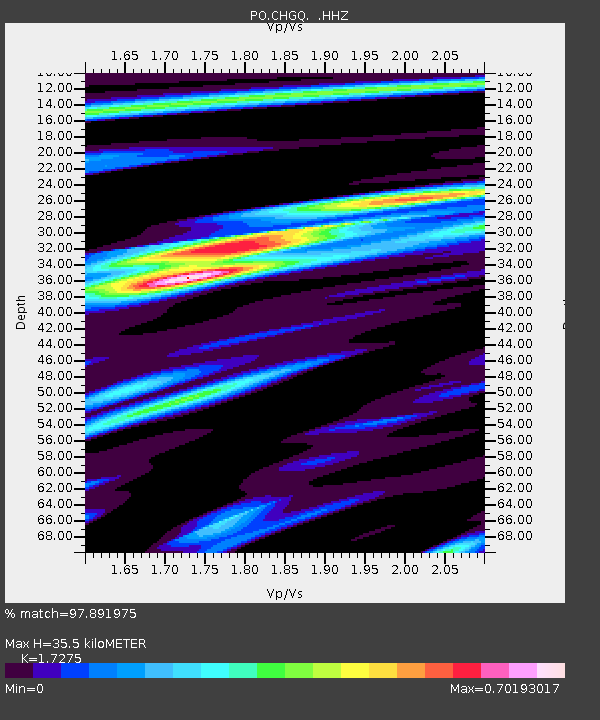
| Estimated Moho Depth: |
35.5 km |
| Estimated Crust Vp/Vs: |
1.73 |
| Assumed Crust Vp: |
6.61 km/s |
| Estimated Crust Vs: |
3.826 km/s |
| Estimated Crust Poisson's Ratio: |
0.25 |
|
| Radial Match: |
97.891975 % |
| Radial Bump: |
281 |
| Transverse Match: |
91.27215 % |
| Transverse Bump: |
400 |
| SOD ConfigId: |
512894 |
| Insert Time: |
2013-09-13 07:27:01.335 +0000 |
| GWidth: |
2.5 |
| Max Bumps: |
400 |
| Tol: |
0.001 |
|

Signal To Noise
| Channel | StoN | STA | LTA |
| PO:CHGQ: :HHZ:20130416T10:56:54.630012Z | 5.607014 | 2.566558E-7 | 4.577406E-8 |
| PO:CHGQ: :HHN:20130416T10:56:54.630012Z | 2.8737652 | 1.448981E-7 | 5.042099E-8 |
| PO:CHGQ: :HHE:20130416T10:56:54.630012Z | 0.812651 | 6.797918E-8 | 8.365114E-8 |
| Arrivals |
| Ps | 4.0 SECOND |
| PpPs | 14 SECOND |
| PsPs/PpSs | 18 SECOND |


