You are here: Home > Network List > RM - Regional Integrated Multi Hazard Early Warning System Stations List
> Station SZP Santa Ilocos Sur > Earthquake Result Viewer
SZP Santa Ilocos Sur - Earthquake Result Viewer
| Earthquake location: |
Southern Iran |
| Earthquake latitude/longitude: |
28.0/62.0 |
| Earthquake time(UTC): |
2013/04/16 (106) 10:44:20 GMT |
| Earthquake Depth: |
80 km |
| Earthquake Magnitude: |
7.7 MW, 7.0 MB, 7.7 MW |
| Earthquake Catalog/Contributor: |
NEIC PDE/NEIC PDE-W |
|
| Network: |
RM Regional Integrated Multi Hazard Early Warning System |
| Station: |
SZP Santa Ilocos Sur |
| Lat/Lon: |
17.55 N/120.46 E |
| Elevation: |
100 m |
|
| Distance: |
54.5 deg |
| Az: |
87.772 deg |
| Baz: |
292.198 deg |
| Ray Param: |
0.06520834 |
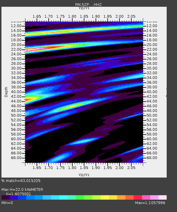
| Estimated Moho Depth: |
22.0 km |
| Estimated Crust Vp/Vs: |
1.61 |
| Assumed Crust Vp: |
6.468 km/s |
| Estimated Crust Vs: |
4.023 km/s |
| Estimated Crust Poisson's Ratio: |
0.18 |
|
| Radial Match: |
83.015205 % |
| Radial Bump: |
400 |
| Transverse Match: |
73.172455 % |
| Transverse Bump: |
400 |
| SOD ConfigId: |
512894 |
| Insert Time: |
2013-09-13 07:27:53.215 +0000 |
| GWidth: |
2.5 |
| Max Bumps: |
400 |
| Tol: |
0.001 |
|

Signal To Noise
| Channel | StoN | STA | LTA |
| RM:SZP: :HHZ:20130416T10:53:08.778022Z | 37.12902 | 2.542552E-5 | 6.8478835E-7 |
| RM:SZP: :HHN:20130416T10:53:08.778022Z | 7.527744 | 1.8570071E-6 | 2.466884E-7 |
| RM:SZP: :HHE:20130416T10:53:08.778022Z | 20.780783 | 8.936205E-6 | 4.3002254E-7 |
| Arrivals |
| Ps | 2.2 SECOND |
| PpPs | 8.4 SECOND |
| PsPs/PpSs | 11 SECOND |


