You are here: Home > Network List > US - United States National Seismic Network Stations List
> Station LBNH Lisbon, New Hampshire, USA > Earthquake Result Viewer
LBNH Lisbon, New Hampshire, USA - Earthquake Result Viewer

| Earthquake location: |
Southern Iran |
| Earthquake latitude/longitude: |
28.0/62.0 |
| Earthquake time(UTC): |
2013/04/16 (106) 10:44:20 GMT |
| Earthquake Depth: |
80 km |
| Earthquake Magnitude: |
7.7 MW, 7.0 MB, 7.7 MW |
| Earthquake Catalog/Contributor: |
NEIC PDE/NEIC PDE-W |
|
| Network: |
US United States National Seismic Network |
| Station: |
LBNH Lisbon, New Hampshire, USA |
| Lat/Lon: |
44.24 N/71.93 W |
| Elevation: |
367 m |
|
| Distance: |
96.6 deg |
| Az: |
328.586 deg |
| Baz: |
39.868 deg |
| Ray Param: |
0.04039336 |
| Estimated Moho Depth: |
25.25 km |
| Estimated Crust Vp/Vs: |
1.98 |
| Assumed Crust Vp: |
6.419 km/s |
| Estimated Crust Vs: |
3.238 km/s |
| Estimated Crust Poisson's Ratio: |
0.33 |
|
| Radial Match: |
97.61166 % |
| Radial Bump: |
353 |
| Transverse Match: |
84.85357 % |
| Transverse Bump: |
400 |
| SOD ConfigId: |
512894 |
| Insert Time: |
2013-09-13 07:29:02.235 +0000 |
| GWidth: |
2.5 |
| Max Bumps: |
400 |
| Tol: |
0.001 |
|
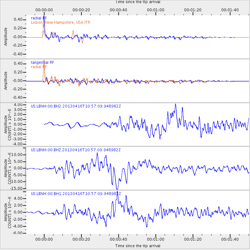
Signal To Noise
| Channel | StoN | STA | LTA |
| US:LBNH:00:BHZ:20130416T10:57:09.948982Z | 1.4578834 | 3.3652165E-7 | 2.3082895E-7 |
| US:LBNH:00:BH1:20130416T10:57:09.948982Z | 0.66379285 | 1.4611149E-7 | 2.2011609E-7 |
| US:LBNH:00:BH2:20130416T10:57:09.948982Z | 0.907172 | 2.6100847E-7 | 2.877166E-7 |
| Arrivals |
| Ps | 3.9 SECOND |
| PpPs | 12 SECOND |
| PsPs/PpSs | 15 SECOND |


