You are here: Home > Network List > YE11 - Testing TA and FA Vaults and Directly Buried Sensors (3T) Stations List
> Station PIC1 Poker Flats, Alaska, USA > Earthquake Result Viewer
PIC1 Poker Flats, Alaska, USA - Earthquake Result Viewer
| Earthquake location: |
Southern Iran |
| Earthquake latitude/longitude: |
28.0/62.0 |
| Earthquake time(UTC): |
2013/04/16 (106) 10:44:20 GMT |
| Earthquake Depth: |
80 km |
| Earthquake Magnitude: |
7.7 MW, 7.0 MB, 7.7 MW |
| Earthquake Catalog/Contributor: |
NEIC PDE/NEIC PDE-W |
|
| Network: |
YE Testing TA and FA Vaults and Directly Buried Sensors (3T) |
| Station: |
PIC1 Poker Flats, Alaska, USA |
| Lat/Lon: |
65.12 N/147.43 W |
| Elevation: |
502 m |
|
| Distance: |
84.4 deg |
| Az: |
12.057 deg |
| Baz: |
334.123 deg |
| Ray Param: |
0.045358315 |
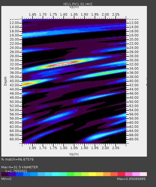
| Estimated Moho Depth: |
31.5 km |
| Estimated Crust Vp/Vs: |
1.80 |
| Assumed Crust Vp: |
6.566 km/s |
| Estimated Crust Vs: |
3.658 km/s |
| Estimated Crust Poisson's Ratio: |
0.27 |
|
| Radial Match: |
96.67576 % |
| Radial Bump: |
400 |
| Transverse Match: |
90.452126 % |
| Transverse Bump: |
400 |
| SOD ConfigId: |
512894 |
| Insert Time: |
2013-09-13 07:29:29.177 +0000 |
| GWidth: |
2.5 |
| Max Bumps: |
400 |
| Tol: |
0.001 |
|

Signal To Noise
| Channel | StoN | STA | LTA |
| YE:PIC1:01:HHZ:20130416T10:56:12.534004Z | 10.738311 | 1.8119259E-6 | 1.6873473E-7 |
| YE:PIC1:01:HHN:20130416T10:56:12.534004Z | 2.0595167 | 3.20986E-7 | 1.55855E-7 |
| YE:PIC1:01:HHE:20130416T10:56:12.534004Z | 1.7489593 | 1.2036294E-7 | 6.881975E-8 |
| Arrivals |
| Ps | 3.9 SECOND |
| PpPs | 13 SECOND |
| PsPs/PpSs | 17 SECOND |


