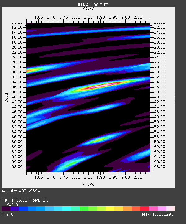
MAJO Matsushiro, Japan - Earthquake Result Viewer
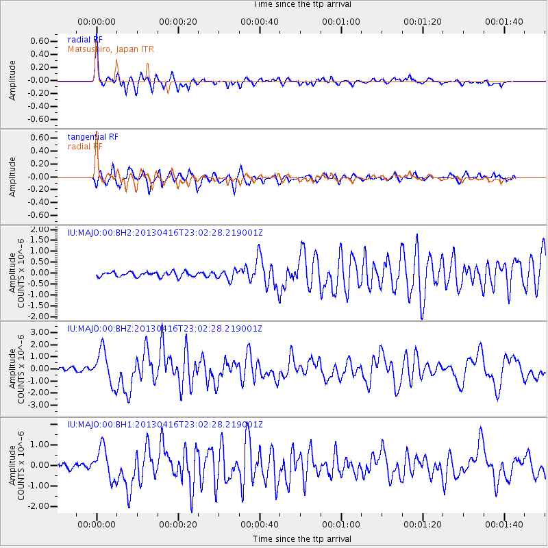
Earthquake location: Near N Coast Of New Guinea, P.N.G.
Earthquake latitude/longitude: -3.2/142.5
Earthquake time(UTC): 2013/04/16 (106) 22:55:26 GMT
Earthquake Depth: 13 km
Earthquake Magnitude: 6.6 MW, 6.1 MB, 6.3 MS, 6.5 MW
Earthquake Catalog/Contributor: NEIC PDE/NEIC PDE-W
Network: IU Global Seismograph Network (GSN - IRIS/USGS)
Station: MAJO Matsushiro, Japan
Lat/Lon: 36.55 N/138.20 E
Elevation: 405 m
Distance: 39.8 deg
Az: 354.535 deg
Baz: 173.219 deg
Ray Param: 0.074789084
Estimated Moho Depth: 35.25 km
Estimated Crust Vp/Vs: 1.90
Assumed Crust Vp: 6.461 km/s
Estimated Crust Vs: 3.401 km/s
Estimated Crust Poisson's Ratio: 0.31
Radial Match: 89.69694 %
Radial Bump: 357
Transverse Match: 82.18527 %
Transverse Bump: 400
SOD ConfigId: 512894
Insert Time: 2013-09-13 07:47:30.079 +0000
GWidth: 2.5
Max Bumps: 400
Tol: 0.001

Signal To Noise

ChannelStoNSTALTA
IU:MAJO:00:BHZ:20130416T23:02:28.219001Z10.9797891.4500712E-61.3206731E-7
IU:MAJO:00:BH1:20130416T23:02:28.219001Z5.92630538.036216E-71.3560248E-7
IU:MAJO:00:BH2:20130416T23:02:28.219001Z1.98611412.13084E-71.0728689E-7
Arrivals
Ps5.2 SECOND
PpPs15 SECOND
PsPs/PpSs20 SECOND