You are here: Home > Network List > UW - Pacific Northwest Regional Seismic Network Stations List
> Station MRBL Marblemount, WA, USA > Earthquake Result Viewer
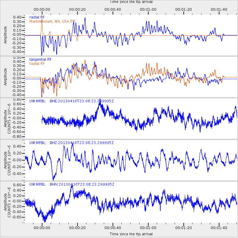
MRBL Marblemount, WA, USA - Earthquake Result Viewer
*The percent match for this event was below the threshold and hence no stack was calculated.
| Earthquake location: |
Near N Coast Of New Guinea, P.N.G. |
| Earthquake latitude/longitude: |
-3.2/142.5 |
| Earthquake time(UTC): |
2013/04/16 (106) 22:55:26 GMT |
| Earthquake Depth: |
13 km |
| Earthquake Magnitude: |
6.6 MW, 6.1 MB, 6.3 MS, 6.5 MW |
| Earthquake Catalog/Contributor: |
NEIC PDE/NEIC PDE-W |
|
| Network: |
UW Pacific Northwest Regional Seismic Network |
| Station: |
MRBL Marblemount, WA, USA |
| Lat/Lon: |
48.52 N/121.48 W |
| Elevation: |
75 m |
|
| Distance: |
96.4 deg |
| Az: |
41.709 deg |
| Baz: |
272.34 deg |
| Ray Param: |
$rayparam |
*The percent match for this event was below the threshold and hence was not used in the summary stack. |
|
| Radial Match: |
58.85948 % |
| Radial Bump: |
397 |
| Transverse Match: |
42.539127 % |
| Transverse Bump: |
400 |
| SOD ConfigId: |
512894 |
| Insert Time: |
2013-09-13 07:53:51.494 +0000 |
| GWidth: |
2.5 |
| Max Bumps: |
400 |
| Tol: |
0.001 |
|
Signal To Noise
| Channel | StoN | STA | LTA |
| UW:MRBL: :BHZ:20130416T23:08:23.299995Z | 1.3434895 | 1.18270876E-7 | 8.803261E-8 |
| UW:MRBL: :BHN:20130416T23:08:23.299995Z | 4.3183336 | 6.7065344E-7 | 1.5530377E-7 |
| UW:MRBL: :BHE:20130416T23:08:23.299995Z | 4.741465 | 5.376744E-7 | 1.1339837E-7 |
| Arrivals |
| Ps | |
| PpPs | |
| PsPs/PpSs | |


