You are here: Home > Network List > TA - USArray Transportable Network (new EarthScope stations) Stations List
> Station G65A Princeton, ME, USA > Earthquake Result Viewer
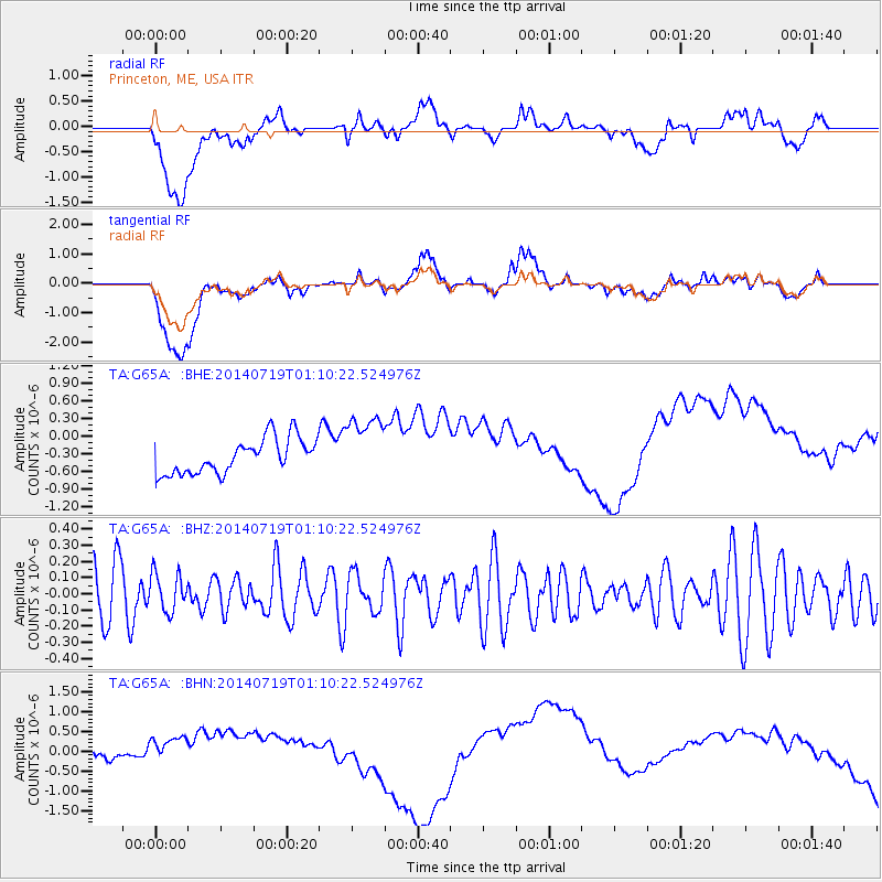
G65A Princeton, ME, USA - Earthquake Result Viewer
*The percent match for this event was below the threshold and hence no stack was calculated.
| Earthquake location: |
Kuril Islands |
| Earthquake latitude/longitude: |
46.2/150.8 |
| Earthquake time(UTC): |
2014/07/19 (200) 00:58:42 GMT |
| Earthquake Depth: |
117 km |
| Earthquake Magnitude: |
3.1 mb, 3.5 mbtmp, 3.2 mb1mx, 3.3 mb1 |
| Earthquake Catalog/Contributor: |
ISC/ISC |
|
| Network: |
TA USArray Transportable Network (new EarthScope stations) |
| Station: |
G65A Princeton, ME, USA |
| Lat/Lon: |
45.20 N/67.56 W |
| Elevation: |
78 m |
|
| Distance: |
82.9 deg |
| Az: |
26.246 deg |
| Baz: |
334.254 deg |
| Ray Param: |
$rayparam |
*The percent match for this event was below the threshold and hence was not used in the summary stack. |
|
| Radial Match: |
7.3435297 % |
| Radial Bump: |
400 |
| Transverse Match: |
7.468713 % |
| Transverse Bump: |
400 |
| SOD ConfigId: |
3390531 |
| Insert Time: |
2019-04-12 22:51:08.420 +0000 |
| GWidth: |
2.5 |
| Max Bumps: |
400 |
| Tol: |
0.001 |
|
Signal To Noise
| Channel | StoN | STA | LTA |
| TA:G65A: :BHZ:20140719T01:10:22.524976Z | 0.6441017 | 1.1627804E-7 | 1.8052746E-7 |
| TA:G65A: :BHN:20140719T01:10:22.524976Z | 2.1217835 | 7.4069567E-7 | 3.4909107E-7 |
| TA:G65A: :BHE:20140719T01:10:22.524976Z | 1.9123393 | 5.6509816E-7 | 2.9550097E-7 |
| Arrivals |
| Ps | |
| PpPs | |
| PsPs/PpSs | |


