You are here: Home > Network List > US - United States National Seismic Network Stations List
> Station GLMI Grayling, Michigan, USA > Earthquake Result Viewer
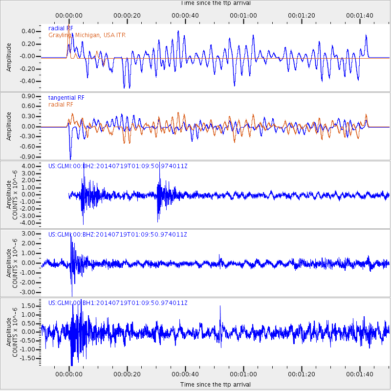
GLMI Grayling, Michigan, USA - Earthquake Result Viewer
*The percent match for this event was below the threshold and hence no stack was calculated.
| Earthquake location: |
Kuril Islands |
| Earthquake latitude/longitude: |
46.2/150.8 |
| Earthquake time(UTC): |
2014/07/19 (200) 00:58:42 GMT |
| Earthquake Depth: |
117 km |
| Earthquake Magnitude: |
3.1 mb, 3.5 mbtmp, 3.2 mb1mx, 3.3 mb1 |
| Earthquake Catalog/Contributor: |
ISC/ISC |
|
| Network: |
US United States National Seismic Network |
| Station: |
GLMI Grayling, Michigan, USA |
| Lat/Lon: |
44.82 N/84.62 W |
| Elevation: |
387 m |
|
| Distance: |
77.0 deg |
| Az: |
36.965 deg |
| Baz: |
324.068 deg |
| Ray Param: |
$rayparam |
*The percent match for this event was below the threshold and hence was not used in the summary stack. |
|
| Radial Match: |
52.900333 % |
| Radial Bump: |
400 |
| Transverse Match: |
55.016705 % |
| Transverse Bump: |
400 |
| SOD ConfigId: |
3390531 |
| Insert Time: |
2019-04-12 22:52:22.039 +0000 |
| GWidth: |
2.5 |
| Max Bumps: |
400 |
| Tol: |
0.001 |
|
Signal To Noise
| Channel | StoN | STA | LTA |
| US:GLMI:00:BHZ:20140719T01:09:50.974011Z | 1.5963788 | 9.1228554E-7 | 5.7147184E-7 |
| US:GLMI:00:BH1:20140719T01:09:50.974011Z | 1.4596007 | 7.4794207E-7 | 5.1242927E-7 |
| US:GLMI:00:BH2:20140719T01:09:50.974011Z | 1.6198077 | 1.1576153E-6 | 7.146622E-7 |
| Arrivals |
| Ps | |
| PpPs | |
| PsPs/PpSs | |


