You are here: Home > Network List > CI - Caltech Regional Seismic Network Stations List
> Station SLA SLA, Trona, CA, USA > Earthquake Result Viewer
SLA SLA, Trona, CA, USA - Earthquake Result Viewer
| Earthquake location: |
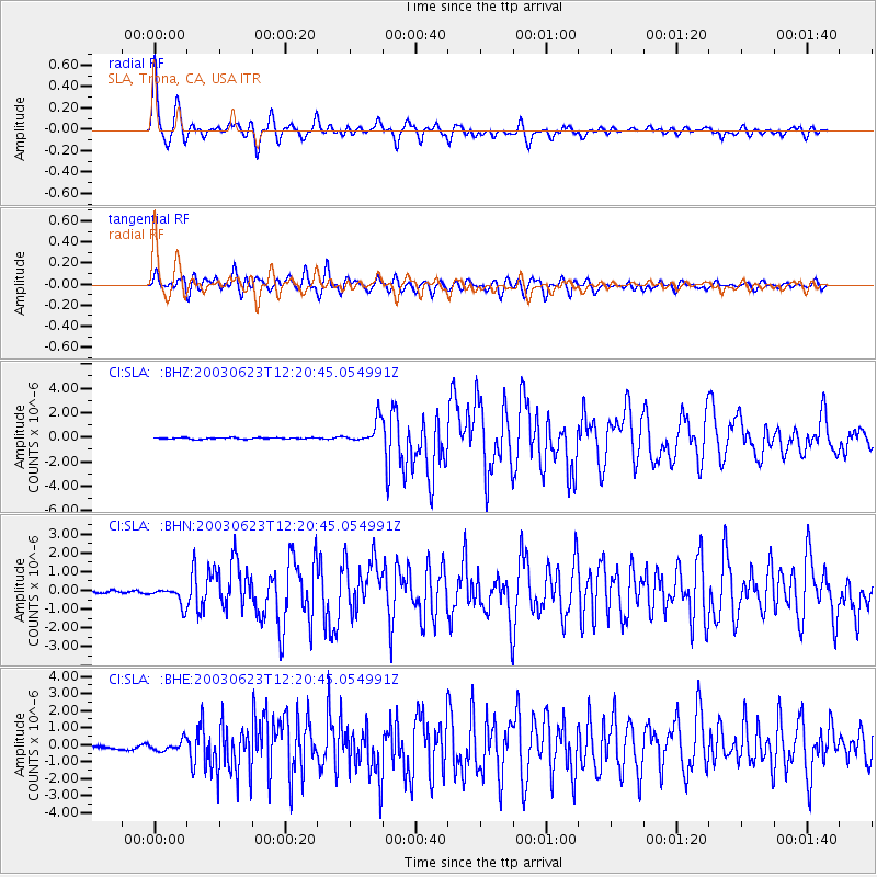
Rat Islands, Aleutian Islands |
| Earthquake latitude/longitude: |
51.4/176.8 |
| Earthquake time(UTC): |
2003/06/23 (174) 12:12:34 GMT |
| Earthquake Depth: |
20 km |
| Earthquake Magnitude: |
6.3 MB, 7.0 MS, 6.9 MW, 6.8 MW |
| Earthquake Catalog/Contributor: |
WHDF/NEIC |
|
| Network: |
CI Caltech Regional Seismic Network |
| Station: |
SLA SLA, Trona, CA, USA |
| Lat/Lon: |
35.89 N/117.28 W |
| Elevation: |
1174 m |
|
| Distance: |
48.5 deg |
| Az: |
81.783 deg |
| Baz: |
310.279 deg |
| Ray Param: |
0.06928562 |
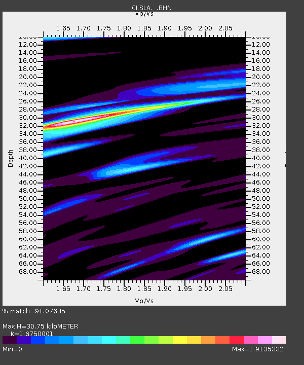
| Estimated Moho Depth: |
30.75 km |
| Estimated Crust Vp/Vs: |
1.68 |
| Assumed Crust Vp: |
6.276 km/s |
| Estimated Crust Vs: |
3.747 km/s |
| Estimated Crust Poisson's Ratio: |
0.22 |
|
| Radial Match: |
91.07635 % |
| Radial Bump: |
400 |
| Transverse Match: |
79.236824 % |
| Transverse Bump: |
400 |
| SOD ConfigId: |
3787 |
| Insert Time: |
2010-02-25 20:30:14.096 +0000 |
| GWidth: |
2.5 |
| Max Bumps: |
400 |
| Tol: |
0.001 |
|
Signal To Noise
| Channel | StoN | STA | LTA |
| CI:SLA: :BHN:20030623T12:20:45.054991Z | 8.875458 | 4.93429E-7 | 5.5594768E-8 |
| CI:SLA: :BHE:20030623T12:20:45.054991Z | 2.0635264 | 3.165772E-7 | 1.5341563E-7 |
| CI:SLA: :BHZ:20030623T12:20:45.054991Z | 17.579576 | 9.625003E-7 | 5.4751055E-8 |
| Arrivals |
| Ps | 3.5 SECOND |
| PpPs | 12 SECOND |
| PsPs/PpSs | 16 SECOND |


