You are here: Home > Network List > TA - USArray Transportable Network (new EarthScope stations) Stations List
> Station L40A Anamosa, IA, USA > Earthquake Result Viewer
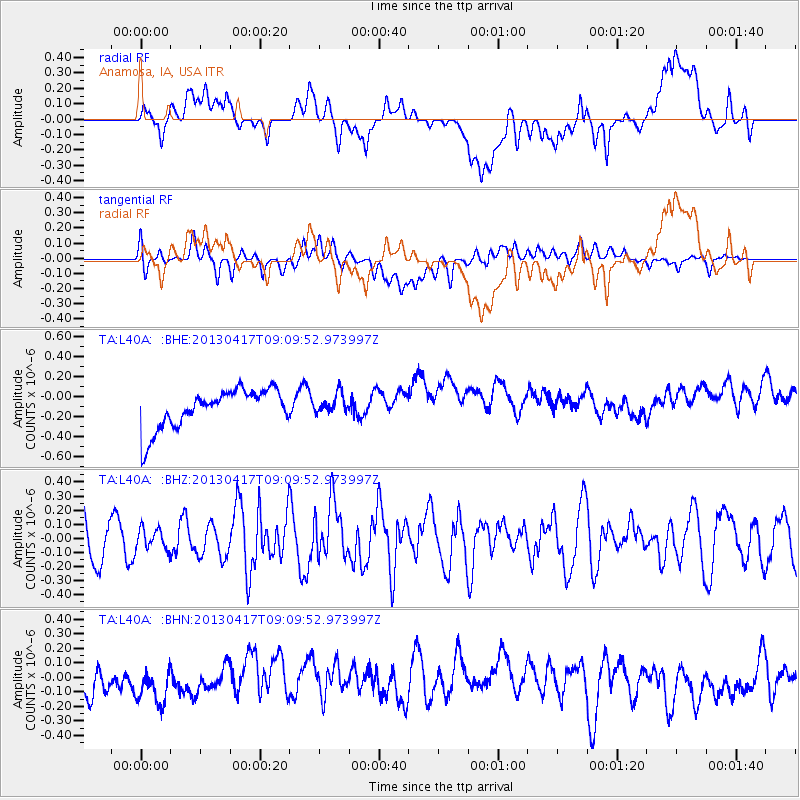
L40A Anamosa, IA, USA - Earthquake Result Viewer
*The percent match for this event was below the threshold and hence no stack was calculated.
| Earthquake location: |
Near S. Coast Of Honshu, Japan |
| Earthquake latitude/longitude: |
34.1/139.4 |
| Earthquake time(UTC): |
2013/04/17 (107) 08:57:19 GMT |
| Earthquake Depth: |
11 km |
| Earthquake Magnitude: |
5.8 MW |
| Earthquake Catalog/Contributor: |
NEIC PDE/NEIC PDE-W |
|
| Network: |
TA USArray Transportable Network (new EarthScope stations) |
| Station: |
L40A Anamosa, IA, USA |
| Lat/Lon: |
42.06 N/91.22 W |
| Elevation: |
242 m |
|
| Distance: |
91.2 deg |
| Az: |
35.127 deg |
| Baz: |
320.097 deg |
| Ray Param: |
$rayparam |
*The percent match for this event was below the threshold and hence was not used in the summary stack. |
|
| Radial Match: |
27.965511 % |
| Radial Bump: |
400 |
| Transverse Match: |
26.029974 % |
| Transverse Bump: |
400 |
| SOD ConfigId: |
512894 |
| Insert Time: |
2013-09-13 08:50:40.823 +0000 |
| GWidth: |
2.5 |
| Max Bumps: |
400 |
| Tol: |
0.001 |
|
Signal To Noise
| Channel | StoN | STA | LTA |
| TA:L40A: :BHZ:20130417T09:09:52.973997Z | 0.5349633 | 7.372027E-8 | 1.3780434E-7 |
| TA:L40A: :BHN:20130417T09:09:52.973997Z | 1.0754567 | 2.1142651E-7 | 1.9659228E-7 |
| TA:L40A: :BHE:20130417T09:09:52.973997Z | 0.4956673 | 9.7036114E-8 | 1.9576864E-7 |
| Arrivals |
| Ps | |
| PpPs | |
| PsPs/PpSs | |


