You are here: Home > Network List > TA - USArray Transportable Network (new EarthScope stations) Stations List
> Station P47A Martinsville, IN, USA > Earthquake Result Viewer
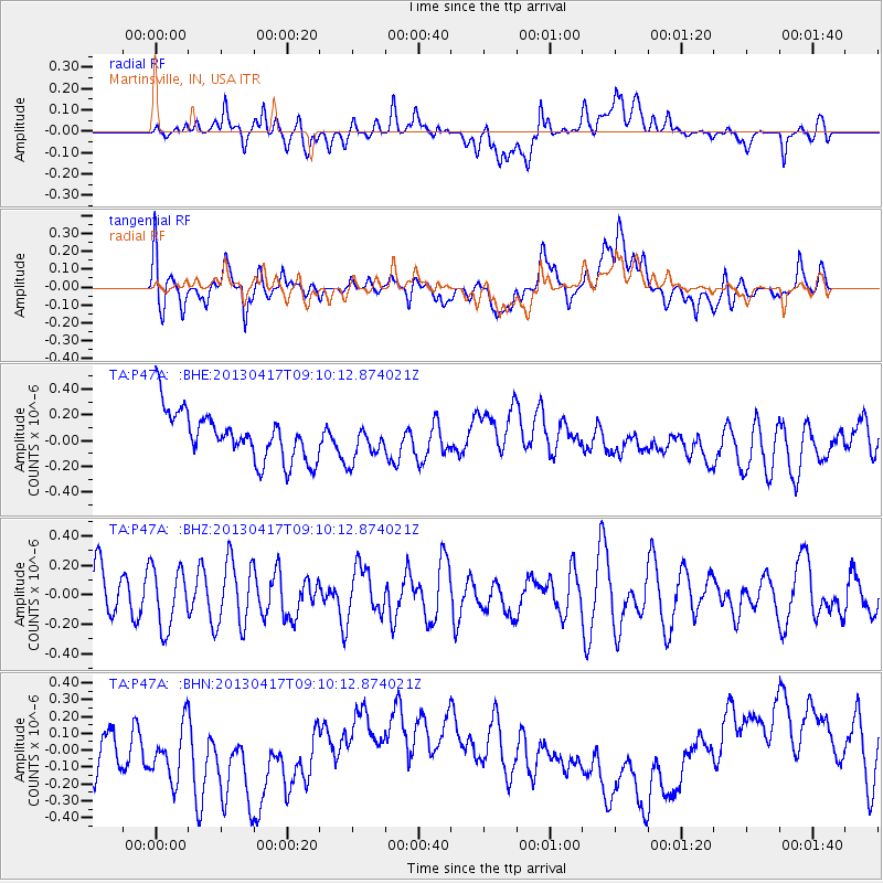
P47A Martinsville, IN, USA - Earthquake Result Viewer
*The percent match for this event was below the threshold and hence no stack was calculated.
| Earthquake location: |
Near S. Coast Of Honshu, Japan |
| Earthquake latitude/longitude: |
34.1/139.4 |
| Earthquake time(UTC): |
2013/04/17 (107) 08:57:19 GMT |
| Earthquake Depth: |
11 km |
| Earthquake Magnitude: |
5.8 MW |
| Earthquake Catalog/Contributor: |
NEIC PDE/NEIC PDE-W |
|
| Network: |
TA USArray Transportable Network (new EarthScope stations) |
| Station: |
P47A Martinsville, IN, USA |
| Lat/Lon: |
39.49 N/86.27 W |
| Elevation: |
246 m |
|
| Distance: |
95.5 deg |
| Az: |
33.764 deg |
| Baz: |
323.4 deg |
| Ray Param: |
$rayparam |
*The percent match for this event was below the threshold and hence was not used in the summary stack. |
|
| Radial Match: |
21.123873 % |
| Radial Bump: |
400 |
| Transverse Match: |
30.921429 % |
| Transverse Bump: |
400 |
| SOD ConfigId: |
512894 |
| Insert Time: |
2013-09-13 08:53:03.928 +0000 |
| GWidth: |
2.5 |
| Max Bumps: |
400 |
| Tol: |
0.001 |
|
Signal To Noise
| Channel | StoN | STA | LTA |
| TA:P47A: :BHZ:20130417T09:10:12.874021Z | 1.0991529 | 2.0342183E-7 | 1.8507144E-7 |
| TA:P47A: :BHN:20130417T09:10:12.874021Z | 1.3068277 | 2.0818896E-7 | 1.5930866E-7 |
| TA:P47A: :BHE:20130417T09:10:12.874021Z | 0.7720922 | 1.4354114E-7 | 1.8591192E-7 |
| Arrivals |
| Ps | |
| PpPs | |
| PsPs/PpSs | |


