You are here: Home > Network List > DK - Danish Seismological Network Stations List
> Station ILULI Ilulissat, Greenland > Earthquake Result Viewer
ILULI Ilulissat, Greenland - Earthquake Result Viewer
| Earthquake location: |
Near East Coast Of Honshu, Japan |
| Earthquake latitude/longitude: |
38.5/141.6 |
| Earthquake time(UTC): |
2013/04/17 (107) 12:03:31 GMT |
| Earthquake Depth: |
50 km |
| Earthquake Magnitude: |
5.9 MW, 5.7 MB, 6.0 MW |
| Earthquake Catalog/Contributor: |
NEIC PDE/NEIC PDE-W |
|
| Network: |
DK Danish Seismological Network |
| Station: |
ILULI Ilulissat, Greenland |
| Lat/Lon: |
69.21 N/51.10 W |
| Elevation: |
54 m |
|
| Distance: |
72.2 deg |
| Az: |
4.741 deg |
| Baz: |
349.531 deg |
| Ray Param: |
0.05371065 |
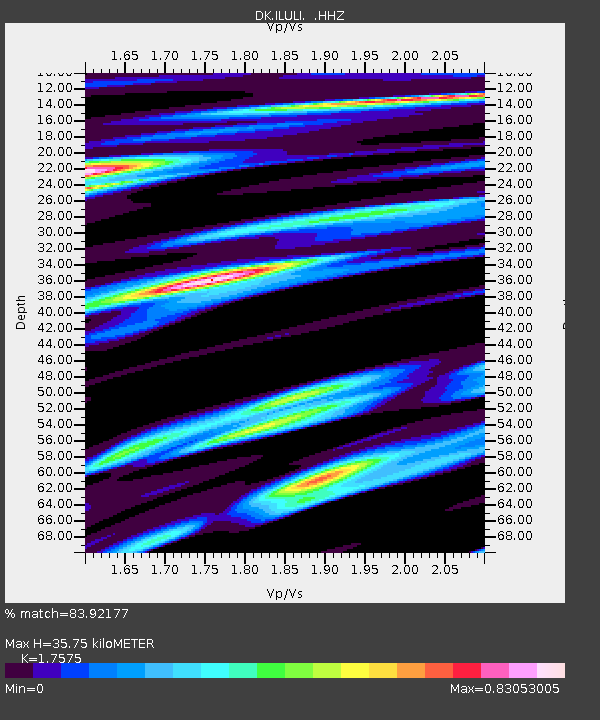
| Estimated Moho Depth: |
35.75 km |
| Estimated Crust Vp/Vs: |
1.76 |
| Assumed Crust Vp: |
6.459 km/s |
| Estimated Crust Vs: |
3.675 km/s |
| Estimated Crust Poisson's Ratio: |
0.26 |
|
| Radial Match: |
83.92177 % |
| Radial Bump: |
376 |
| Transverse Match: |
72.02629 % |
| Transverse Bump: |
312 |
| SOD ConfigId: |
512894 |
| Insert Time: |
2013-09-13 09:13:54.745 +0000 |
| GWidth: |
2.5 |
| Max Bumps: |
400 |
| Tol: |
0.001 |
|

Signal To Noise
| Channel | StoN | STA | LTA |
| DK:ILULI: :HHZ:20130417T12:14:20.569998Z | 1.9997537 | 5.4127713E-7 | 2.706719E-7 |
| DK:ILULI: :HHN:20130417T12:14:20.569998Z | 1.9402297 | 3.849701E-7 | 1.9841471E-7 |
| DK:ILULI: :HHE:20130417T12:14:20.569998Z | 0.82427555 | 1.822209E-7 | 2.2106795E-7 |
| Arrivals |
| Ps | 4.3 SECOND |
| PpPs | 15 SECOND |
| PsPs/PpSs | 19 SECOND |


