You are here: Home > Network List > KR - Kyrgyz Digital Network Stations List
> Station BOOM Boom, Kyrgyzstan > Earthquake Result Viewer
BOOM Boom, Kyrgyzstan - Earthquake Result Viewer

| Earthquake location: |
Near East Coast Of Honshu, Japan |
| Earthquake latitude/longitude: |
38.5/141.6 |
| Earthquake time(UTC): |
2013/04/17 (107) 12:03:31 GMT |
| Earthquake Depth: |
50 km |
| Earthquake Magnitude: |
5.9 MW, 5.7 MB, 6.0 MW |
| Earthquake Catalog/Contributor: |
NEIC PDE/NEIC PDE-W |
|
| Network: |
KR Kyrgyz Digital Network |
| Station: |
BOOM Boom, Kyrgyzstan |
| Lat/Lon: |
42.49 N/75.94 E |
| Elevation: |
1737 m |
|
| Distance: |
49.0 deg |
| Az: |
296.737 deg |
| Baz: |
71.392 deg |
| Ray Param: |
0.06884805 |
| Estimated Moho Depth: |
38.75 km |
| Estimated Crust Vp/Vs: |
1.73 |
| Assumed Crust Vp: |
6.306 km/s |
| Estimated Crust Vs: |
3.645 km/s |
| Estimated Crust Poisson's Ratio: |
0.25 |
|
| Radial Match: |
91.739006 % |
| Radial Bump: |
400 |
| Transverse Match: |
82.05578 % |
| Transverse Bump: |
400 |
| SOD ConfigId: |
512894 |
| Insert Time: |
2013-09-13 09:22:04.386 +0000 |
| GWidth: |
2.5 |
| Max Bumps: |
400 |
| Tol: |
0.001 |
|
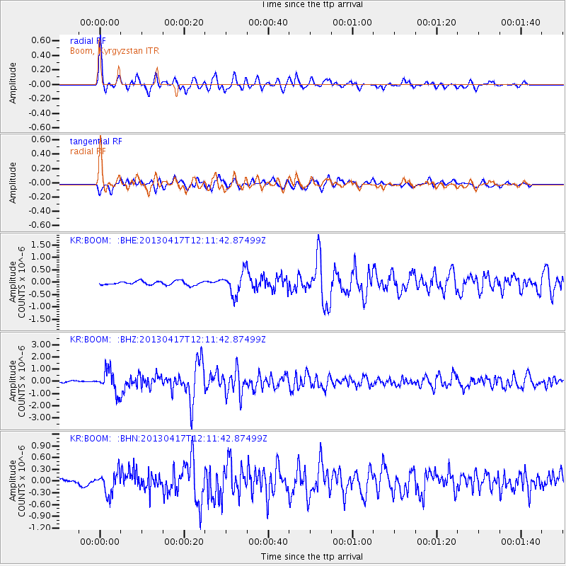
Signal To Noise
| Channel | StoN | STA | LTA |
| KR:BOOM: :BHZ:20130417T12:11:42.87499Z | 14.773933 | 9.394674E-7 | 6.3589525E-8 |
| KR:BOOM: :BHN:20130417T12:11:42.87499Z | 4.1035047 | 2.868799E-7 | 6.991094E-8 |
| KR:BOOM: :BHE:20130417T12:11:42.87499Z | 6.1576223 | 4.6138032E-7 | 7.492832E-8 |
| Arrivals |
| Ps | 4.8 SECOND |
| PpPs | 16 SECOND |
| PsPs/PpSs | 21 SECOND |


