You are here: Home > Network List > TA - USArray Transportable Network (new EarthScope stations) Stations List
> Station G59A Clarenceville, QC, USA > Earthquake Result Viewer
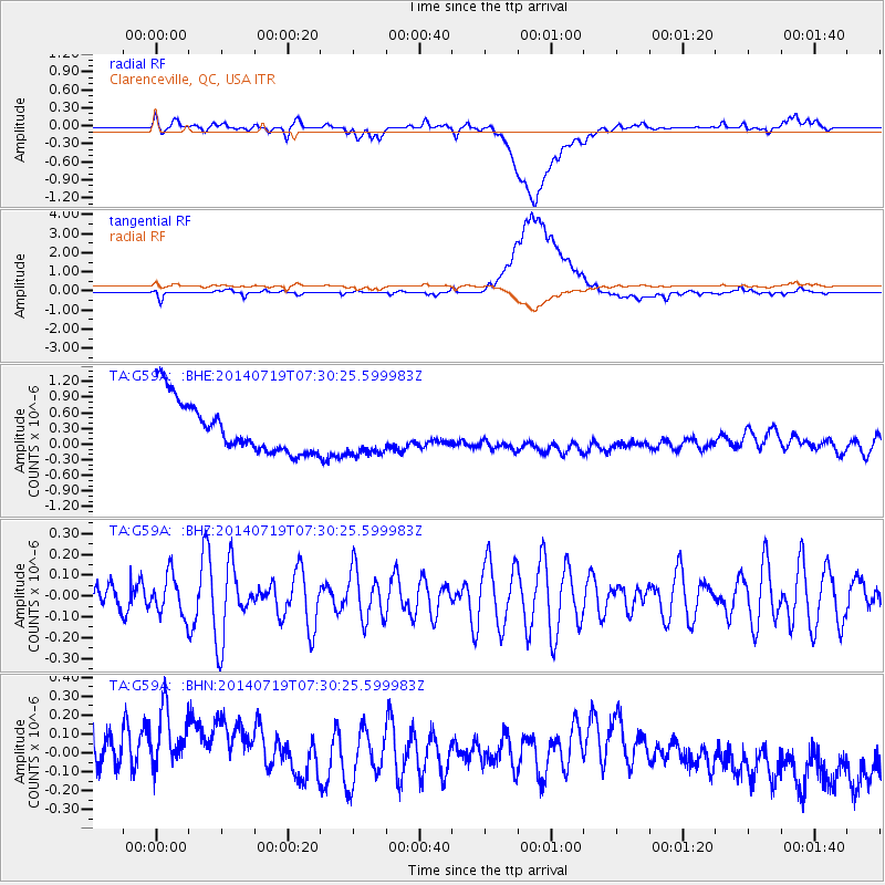
G59A Clarenceville, QC, USA - Earthquake Result Viewer
*The percent match for this event was below the threshold and hence no stack was calculated.
| Earthquake location: |
Afghanistan-Tajikistan Bord Reg. |
| Earthquake latitude/longitude: |
36.9/71.1 |
| Earthquake time(UTC): |
2014/07/19 (200) 07:17:56 GMT |
| Earthquake Depth: |
84 km |
| Earthquake Magnitude: |
5.3 MW, 5.2 Mwb, 5.3 mb |
| Earthquake Catalog/Contributor: |
ISC/ISC |
|
| Network: |
TA USArray Transportable Network (new EarthScope stations) |
| Station: |
G59A Clarenceville, QC, USA |
| Lat/Lon: |
45.08 N/73.18 W |
| Elevation: |
36 m |
|
| Distance: |
92.3 deg |
| Az: |
335.546 deg |
| Baz: |
27.937 deg |
| Ray Param: |
$rayparam |
*The percent match for this event was below the threshold and hence was not used in the summary stack. |
|
| Radial Match: |
25.941254 % |
| Radial Bump: |
400 |
| Transverse Match: |
41.291237 % |
| Transverse Bump: |
400 |
| SOD ConfigId: |
3390531 |
| Insert Time: |
2019-04-12 23:04:03.661 +0000 |
| GWidth: |
2.5 |
| Max Bumps: |
400 |
| Tol: |
0.001 |
|
Signal To Noise
| Channel | StoN | STA | LTA |
| TA:G59A: :BHZ:20140719T07:30:25.599983Z | 0.7996015 | 9.582627E-8 | 1.1984254E-7 |
| TA:G59A: :BHN:20140719T07:30:25.599983Z | 0.94432867 | 4.5889638E-7 | 4.8594984E-7 |
| TA:G59A: :BHE:20140719T07:30:25.599983Z | 0.86043286 | 4.2200907E-7 | 4.9046133E-7 |
| Arrivals |
| Ps | |
| PpPs | |
| PsPs/PpSs | |


