You are here: Home > Network List > 3C - Arizona Rapid Array Array Mobilization Program Stations List
> Station DUN1 Lazy B, AZ, USA > Earthquake Result Viewer
DUN1 Lazy B, AZ, USA - Earthquake Result Viewer
| Earthquake location: |
Tonga Islands |
| Earthquake latitude/longitude: |
-15.8/-174.4 |
| Earthquake time(UTC): |
2014/07/19 (200) 12:27:09 GMT |
| Earthquake Depth: |
220 km |
| Earthquake Magnitude: |
6.0 MWP |
| Earthquake Catalog/Contributor: |
NEIC PDE/NEIC COMCAT |
|
| Network: |
3C Arizona Rapid Array Array Mobilization Program |
| Station: |
DUN1 Lazy B, AZ, USA |
| Lat/Lon: |
32.55 N/109.09 W |
| Elevation: |
1257 m |
|
| Distance: |
78.8 deg |
| Az: |
51.472 deg |
| Baz: |
243.097 deg |
| Ray Param: |
0.048850074 |
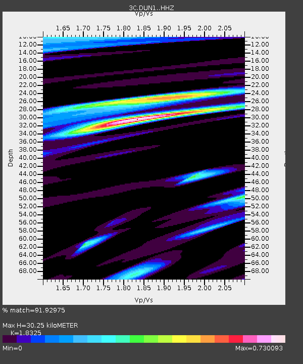
| Estimated Moho Depth: |
30.25 km |
| Estimated Crust Vp/Vs: |
1.83 |
| Assumed Crust Vp: |
6.276 km/s |
| Estimated Crust Vs: |
3.425 km/s |
| Estimated Crust Poisson's Ratio: |
0.29 |
|
| Radial Match: |
91.92975 % |
| Radial Bump: |
398 |
| Transverse Match: |
82.91191 % |
| Transverse Bump: |
400 |
| SOD ConfigId: |
3390531 |
| Insert Time: |
2019-04-12 23:06:18.477 +0000 |
| GWidth: |
2.5 |
| Max Bumps: |
400 |
| Tol: |
0.001 |
|

Signal To Noise
| Channel | StoN | STA | LTA |
| 3C:DUN1: :HHZ:20140719T12:38:16.535015Z | 15.599324 | 1.092407E-6 | 7.0029124E-8 |
| 3C:DUN1: :HHN:20140719T12:38:16.535015Z | 2.1996877 | 1.5908142E-7 | 7.2320006E-8 |
| 3C:DUN1: :HHE:20140719T12:38:16.535015Z | 5.0359178 | 2.424048E-7 | 4.813518E-8 |
| Arrivals |
| Ps | 4.1 SECOND |
| PpPs | 13 SECOND |
| PsPs/PpSs | 17 SECOND |


