You are here: Home > Network List > TA - USArray Transportable Network (new EarthScope stations) Stations List
> Station F39A Loretta, WI, USA > Earthquake Result Viewer
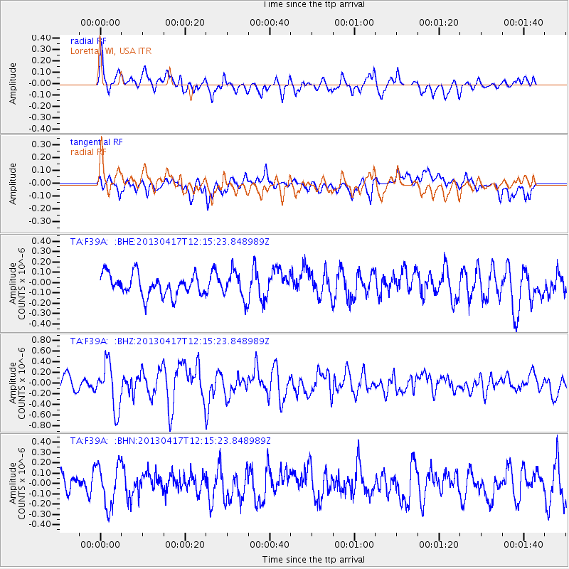
F39A Loretta, WI, USA - Earthquake Result Viewer
*The percent match for this event was below the threshold and hence no stack was calculated.
| Earthquake location: |
Near East Coast Of Honshu, Japan |
| Earthquake latitude/longitude: |
38.5/141.6 |
| Earthquake time(UTC): |
2013/04/17 (107) 12:03:31 GMT |
| Earthquake Depth: |
50 km |
| Earthquake Magnitude: |
5.9 MW, 5.7 MB, 6.0 MW |
| Earthquake Catalog/Contributor: |
NEIC PDE/NEIC PDE-W |
|
| Network: |
TA USArray Transportable Network (new EarthScope stations) |
| Station: |
F39A Loretta, WI, USA |
| Lat/Lon: |
45.92 N/90.92 W |
| Elevation: |
440 m |
|
| Distance: |
83.7 deg |
| Az: |
33.892 deg |
| Baz: |
321.174 deg |
| Ray Param: |
$rayparam |
*The percent match for this event was below the threshold and hence was not used in the summary stack. |
|
| Radial Match: |
57.32341 % |
| Radial Bump: |
400 |
| Transverse Match: |
64.19321 % |
| Transverse Bump: |
400 |
| SOD ConfigId: |
512894 |
| Insert Time: |
2013-09-13 09:34:04.668 +0000 |
| GWidth: |
2.5 |
| Max Bumps: |
400 |
| Tol: |
0.001 |
|
Signal To Noise
| Channel | StoN | STA | LTA |
| TA:F39A: :BHZ:20130417T12:15:23.848989Z | 3.53362 | 4.3200225E-7 | 1.2225487E-7 |
| TA:F39A: :BHN:20130417T12:15:23.848989Z | 1.8385627 | 2.034891E-7 | 1.1067836E-7 |
| TA:F39A: :BHE:20130417T12:15:23.848989Z | 1.3336803 | 1.3455742E-7 | 1.0089182E-7 |
| Arrivals |
| Ps | |
| PpPs | |
| PsPs/PpSs | |


