You are here: Home > Network List > TA - USArray Transportable Network (new EarthScope stations) Stations List
> Station H47A Mio, MI, USA > Earthquake Result Viewer
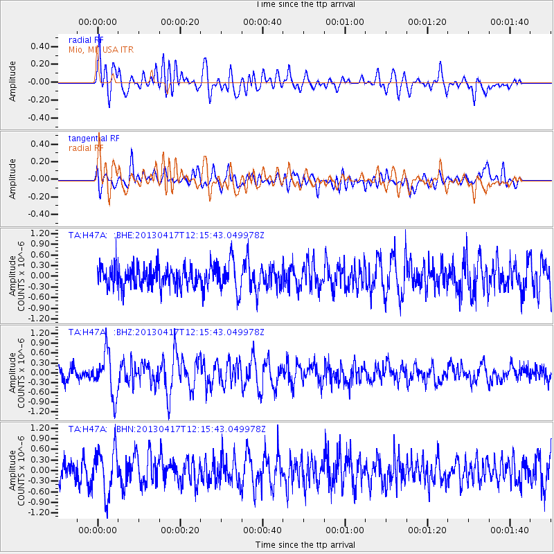
H47A Mio, MI, USA - Earthquake Result Viewer
*The percent match for this event was below the threshold and hence no stack was calculated.
| Earthquake location: |
Near East Coast Of Honshu, Japan |
| Earthquake latitude/longitude: |
38.5/141.6 |
| Earthquake time(UTC): |
2013/04/17 (107) 12:03:31 GMT |
| Earthquake Depth: |
50 km |
| Earthquake Magnitude: |
5.9 MW, 5.7 MB, 6.0 MW |
| Earthquake Catalog/Contributor: |
NEIC PDE/NEIC PDE-W |
|
| Network: |
TA USArray Transportable Network (new EarthScope stations) |
| Station: |
H47A Mio, MI, USA |
| Lat/Lon: |
44.60 N/84.21 W |
| Elevation: |
356 m |
|
| Distance: |
87.5 deg |
| Az: |
30.86 deg |
| Baz: |
325.697 deg |
| Ray Param: |
$rayparam |
*The percent match for this event was below the threshold and hence was not used in the summary stack. |
|
| Radial Match: |
51.437084 % |
| Radial Bump: |
400 |
| Transverse Match: |
60.34419 % |
| Transverse Bump: |
400 |
| SOD ConfigId: |
512894 |
| Insert Time: |
2013-09-13 09:36:08.381 +0000 |
| GWidth: |
2.5 |
| Max Bumps: |
400 |
| Tol: |
0.001 |
|
Signal To Noise
| Channel | StoN | STA | LTA |
| TA:H47A: :BHZ:20130417T12:15:43.049978Z | 3.3387244 | 6.8505955E-7 | 2.0518601E-7 |
| TA:H47A: :BHN:20130417T12:15:43.049978Z | 1.9900887 | 6.3967093E-7 | 3.2142836E-7 |
| TA:H47A: :BHE:20130417T12:15:43.049978Z | 1.6461893 | 4.609749E-7 | 2.8002543E-7 |
| Arrivals |
| Ps | |
| PpPs | |
| PsPs/PpSs | |


