You are here: Home > Network List > TA - USArray Transportable Network (new EarthScope stations) Stations List
> Station J41A Loganville, WI, USA > Earthquake Result Viewer
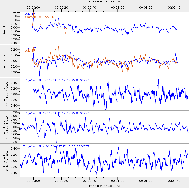
J41A Loganville, WI, USA - Earthquake Result Viewer
*The percent match for this event was below the threshold and hence no stack was calculated.
| Earthquake location: |
Near East Coast Of Honshu, Japan |
| Earthquake latitude/longitude: |
38.5/141.6 |
| Earthquake time(UTC): |
2013/04/17 (107) 12:03:31 GMT |
| Earthquake Depth: |
50 km |
| Earthquake Magnitude: |
5.9 MW, 5.7 MB, 6.0 MW |
| Earthquake Catalog/Contributor: |
NEIC PDE/NEIC PDE-W |
|
| Network: |
TA USArray Transportable Network (new EarthScope stations) |
| Station: |
J41A Loganville, WI, USA |
| Lat/Lon: |
43.37 N/90.01 W |
| Elevation: |
360 m |
|
| Distance: |
86.1 deg |
| Az: |
34.976 deg |
| Baz: |
321.906 deg |
| Ray Param: |
$rayparam |
*The percent match for this event was below the threshold and hence was not used in the summary stack. |
|
| Radial Match: |
51.602146 % |
| Radial Bump: |
400 |
| Transverse Match: |
58.379345 % |
| Transverse Bump: |
400 |
| SOD ConfigId: |
512894 |
| Insert Time: |
2013-09-13 09:37:56.875 +0000 |
| GWidth: |
2.5 |
| Max Bumps: |
400 |
| Tol: |
0.001 |
|
Signal To Noise
| Channel | StoN | STA | LTA |
| TA:J41A: :BHZ:20130417T12:15:35.850027Z | 3.3080008 | 4.0987288E-7 | 1.239035E-7 |
| TA:J41A: :BHN:20130417T12:15:35.850027Z | 1.4391402 | 2.8328097E-7 | 1.9684043E-7 |
| TA:J41A: :BHE:20130417T12:15:35.850027Z | 1.3693767 | 1.7301457E-7 | 1.2634548E-7 |
| Arrivals |
| Ps | |
| PpPs | |
| PsPs/PpSs | |


