You are here: Home > Network List > TA - USArray Transportable Network (new EarthScope stations) Stations List
> Station K40A Colesburg, IA, USA > Earthquake Result Viewer
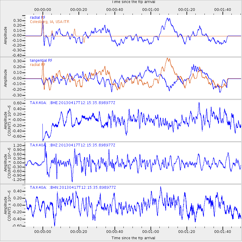
K40A Colesburg, IA, USA - Earthquake Result Viewer
*The percent match for this event was below the threshold and hence no stack was calculated.
| Earthquake location: |
Near East Coast Of Honshu, Japan |
| Earthquake latitude/longitude: |
38.5/141.6 |
| Earthquake time(UTC): |
2013/04/17 (107) 12:03:31 GMT |
| Earthquake Depth: |
50 km |
| Earthquake Magnitude: |
5.9 MW, 5.7 MB, 6.0 MW |
| Earthquake Catalog/Contributor: |
NEIC PDE/NEIC PDE-W |
|
| Network: |
TA USArray Transportable Network (new EarthScope stations) |
| Station: |
K40A Colesburg, IA, USA |
| Lat/Lon: |
42.70 N/91.14 W |
| Elevation: |
274 m |
|
| Distance: |
86.1 deg |
| Az: |
36.038 deg |
| Baz: |
321.214 deg |
| Ray Param: |
$rayparam |
*The percent match for this event was below the threshold and hence was not used in the summary stack. |
|
| Radial Match: |
46.856895 % |
| Radial Bump: |
400 |
| Transverse Match: |
53.65316 % |
| Transverse Bump: |
400 |
| SOD ConfigId: |
512894 |
| Insert Time: |
2013-09-13 09:38:43.979 +0000 |
| GWidth: |
2.5 |
| Max Bumps: |
400 |
| Tol: |
0.001 |
|
Signal To Noise
| Channel | StoN | STA | LTA |
| TA:K40A: :BHZ:20130417T12:15:35.898977Z | 3.5145967 | 5.752917E-7 | 1.6368641E-7 |
| TA:K40A: :BHN:20130417T12:15:35.898977Z | 0.64156926 | 1.5614691E-7 | 2.4338277E-7 |
| TA:K40A: :BHE:20130417T12:15:35.898977Z | 0.62130684 | 1.7060107E-7 | 2.7458424E-7 |
| Arrivals |
| Ps | |
| PpPs | |
| PsPs/PpSs | |


