You are here: Home > Network List > US - United States National Seismic Network Stations List
> Station DGMT Dagmar, Montana, USA > Earthquake Result Viewer
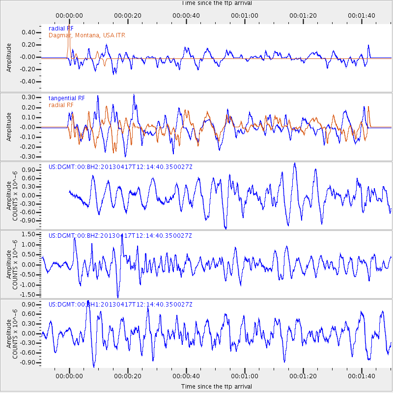
DGMT Dagmar, Montana, USA - Earthquake Result Viewer
*The percent match for this event was below the threshold and hence no stack was calculated.
| Earthquake location: |
Near East Coast Of Honshu, Japan |
| Earthquake latitude/longitude: |
38.5/141.6 |
| Earthquake time(UTC): |
2013/04/17 (107) 12:03:31 GMT |
| Earthquake Depth: |
50 km |
| Earthquake Magnitude: |
5.9 MW, 5.7 MB, 6.0 MW |
| Earthquake Catalog/Contributor: |
NEIC PDE/NEIC PDE-W |
|
| Network: |
US United States National Seismic Network |
| Station: |
DGMT Dagmar, Montana, USA |
| Lat/Lon: |
48.47 N/104.20 W |
| Elevation: |
0.0 m |
|
| Distance: |
75.6 deg |
| Az: |
38.815 deg |
| Baz: |
312.33 deg |
| Ray Param: |
$rayparam |
*The percent match for this event was below the threshold and hence was not used in the summary stack. |
|
| Radial Match: |
58.375397 % |
| Radial Bump: |
400 |
| Transverse Match: |
46.17458 % |
| Transverse Bump: |
361 |
| SOD ConfigId: |
512894 |
| Insert Time: |
2013-09-13 09:50:27.922 +0000 |
| GWidth: |
2.5 |
| Max Bumps: |
400 |
| Tol: |
0.001 |
|
Signal To Noise
| Channel | StoN | STA | LTA |
| US:DGMT:00:BHZ:20130417T12:14:40.350027Z | 3.0709665 | 6.008797E-7 | 1.9566468E-7 |
| US:DGMT:00:BH1:20130417T12:14:40.350027Z | 0.70489657 | 1.9452743E-7 | 2.7596593E-7 |
| US:DGMT:00:BH2:20130417T12:14:40.350027Z | 0.7745629 | 2.2509317E-7 | 2.9060672E-7 |
| Arrivals |
| Ps | |
| PpPs | |
| PsPs/PpSs | |


