You are here: Home > Network List > US - United States National Seismic Network Stations List
> Station ERPA Erie, Pennsylvania, USA > Earthquake Result Viewer
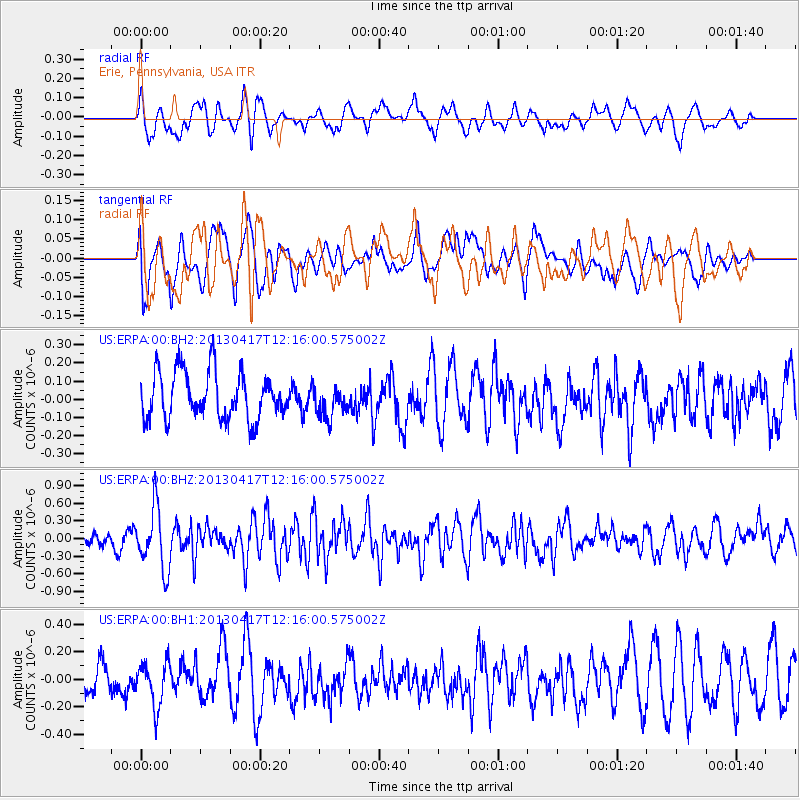
ERPA Erie, Pennsylvania, USA - Earthquake Result Viewer
*The percent match for this event was below the threshold and hence no stack was calculated.
| Earthquake location: |
Near East Coast Of Honshu, Japan |
| Earthquake latitude/longitude: |
38.5/141.6 |
| Earthquake time(UTC): |
2013/04/17 (107) 12:03:31 GMT |
| Earthquake Depth: |
50 km |
| Earthquake Magnitude: |
5.9 MW, 5.7 MB, 6.0 MW |
| Earthquake Catalog/Contributor: |
NEIC PDE/NEIC PDE-W |
|
| Network: |
US United States National Seismic Network |
| Station: |
ERPA Erie, Pennsylvania, USA |
| Lat/Lon: |
42.12 N/79.99 W |
| Elevation: |
306 m |
|
| Distance: |
91.3 deg |
| Az: |
29.622 deg |
| Baz: |
328.57 deg |
| Ray Param: |
$rayparam |
*The percent match for this event was below the threshold and hence was not used in the summary stack. |
|
| Radial Match: |
50.82329 % |
| Radial Bump: |
391 |
| Transverse Match: |
62.015095 % |
| Transverse Bump: |
400 |
| SOD ConfigId: |
512894 |
| Insert Time: |
2013-09-13 09:50:40.309 +0000 |
| GWidth: |
2.5 |
| Max Bumps: |
400 |
| Tol: |
0.001 |
|
Signal To Noise
| Channel | StoN | STA | LTA |
| US:ERPA:00:BHZ:20130417T12:16:00.575002Z | 3.5808508 | 5.259664E-7 | 1.4688308E-7 |
| US:ERPA:00:BH1:20130417T12:16:00.575002Z | 0.77881956 | 1.5928438E-7 | 2.0452026E-7 |
| US:ERPA:00:BH2:20130417T12:16:00.575002Z | 0.6728627 | 8.606935E-8 | 1.2791517E-7 |
| Arrivals |
| Ps | |
| PpPs | |
| PsPs/PpSs | |


