You are here: Home > Network List > US - United States National Seismic Network Stations List
> Station MSO Missoula, Montana, USA > Earthquake Result Viewer
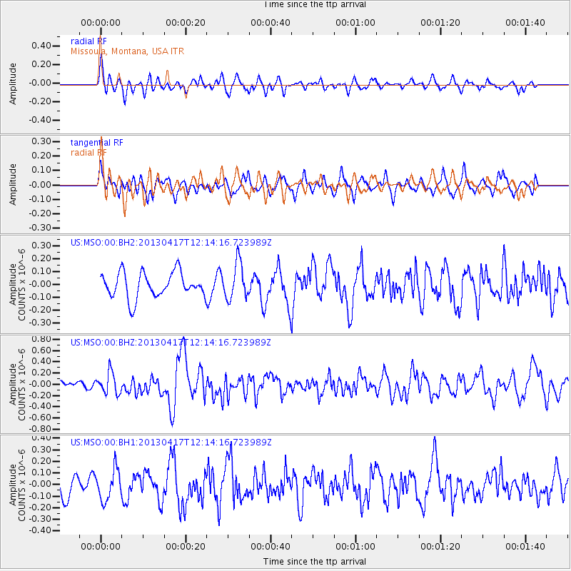
MSO Missoula, Montana, USA - Earthquake Result Viewer
*The percent match for this event was below the threshold and hence no stack was calculated.
| Earthquake location: |
Near East Coast Of Honshu, Japan |
| Earthquake latitude/longitude: |
38.5/141.6 |
| Earthquake time(UTC): |
2013/04/17 (107) 12:03:31 GMT |
| Earthquake Depth: |
50 km |
| Earthquake Magnitude: |
5.9 MW, 5.7 MB, 6.0 MW |
| Earthquake Catalog/Contributor: |
NEIC PDE/NEIC PDE-W |
|
| Network: |
US United States National Seismic Network |
| Station: |
MSO Missoula, Montana, USA |
| Lat/Lon: |
46.83 N/113.94 W |
| Elevation: |
1264 m |
|
| Distance: |
71.6 deg |
| Az: |
44.5 deg |
| Baz: |
306.75 deg |
| Ray Param: |
$rayparam |
*The percent match for this event was below the threshold and hence was not used in the summary stack. |
|
| Radial Match: |
54.699806 % |
| Radial Bump: |
400 |
| Transverse Match: |
54.93757 % |
| Transverse Bump: |
400 |
| SOD ConfigId: |
512894 |
| Insert Time: |
2013-09-13 09:51:31.955 +0000 |
| GWidth: |
2.5 |
| Max Bumps: |
400 |
| Tol: |
0.001 |
|
Signal To Noise
| Channel | StoN | STA | LTA |
| US:MSO:00:BHZ:20130417T12:14:16.723989Z | 2.2475226 | 1.9232105E-7 | 8.557024E-8 |
| US:MSO:00:BH1:20130417T12:14:16.723989Z | 1.790843 | 1.3416987E-7 | 7.4919946E-8 |
| US:MSO:00:BH2:20130417T12:14:16.723989Z | 1.4696939 | 1.4439337E-7 | 9.824725E-8 |
| Arrivals |
| Ps | |
| PpPs | |
| PsPs/PpSs | |


