You are here: Home > Network List > US - United States National Seismic Network Stations List
> Station SCIA State Center, Iowa, USA > Earthquake Result Viewer
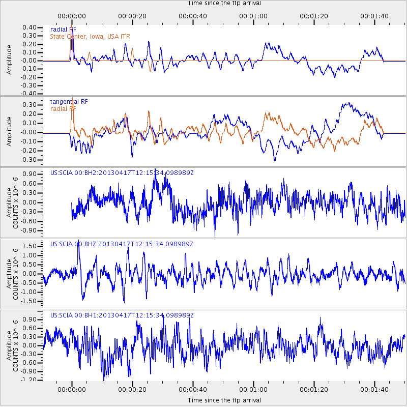
SCIA State Center, Iowa, USA - Earthquake Result Viewer
*The percent match for this event was below the threshold and hence no stack was calculated.
| Earthquake location: |
Near East Coast Of Honshu, Japan |
| Earthquake latitude/longitude: |
38.5/141.6 |
| Earthquake time(UTC): |
2013/04/17 (107) 12:03:31 GMT |
| Earthquake Depth: |
50 km |
| Earthquake Magnitude: |
5.9 MW, 5.7 MB, 6.0 MW |
| Earthquake Catalog/Contributor: |
NEIC PDE/NEIC PDE-W |
|
| Network: |
US United States National Seismic Network |
| Station: |
SCIA State Center, Iowa, USA |
| Lat/Lon: |
41.91 N/93.22 W |
| Elevation: |
312 m |
|
| Distance: |
85.7 deg |
| Az: |
37.736 deg |
| Baz: |
319.943 deg |
| Ray Param: |
$rayparam |
*The percent match for this event was below the threshold and hence was not used in the summary stack. |
|
| Radial Match: |
50.74201 % |
| Radial Bump: |
400 |
| Transverse Match: |
43.328194 % |
| Transverse Bump: |
400 |
| SOD ConfigId: |
512894 |
| Insert Time: |
2013-09-13 09:51:52.217 +0000 |
| GWidth: |
2.5 |
| Max Bumps: |
400 |
| Tol: |
0.001 |
|
Signal To Noise
| Channel | StoN | STA | LTA |
| US:SCIA:00:BHZ:20130417T12:15:34.098989Z | 3.8602574 | 7.678533E-7 | 1.9891246E-7 |
| US:SCIA:00:BH1:20130417T12:15:34.098989Z | 1.3597583 | 3.875906E-7 | 2.8504377E-7 |
| US:SCIA:00:BH2:20130417T12:15:34.098989Z | 1.7869322 | 4.6372512E-7 | 2.5950908E-7 |
| Arrivals |
| Ps | |
| PpPs | |
| PsPs/PpSs | |


