You are here: Home > Network List > XD14 - Illuminating the architecture of the greater Mount St. Helens magmatic systems f Stations List
> Station MG03 "Mount St Helens, WA" > Earthquake Result Viewer
MG03 "Mount St Helens, WA" - Earthquake Result Viewer
| Earthquake location: |
Tonga Islands |
| Earthquake latitude/longitude: |
-15.8/-174.4 |
| Earthquake time(UTC): |
2014/07/19 (200) 12:27:09 GMT |
| Earthquake Depth: |
220 km |
| Earthquake Magnitude: |
6.0 MWP |
| Earthquake Catalog/Contributor: |
NEIC PDE/NEIC COMCAT |
|
| Network: |
XD Illuminating the architecture of the greater Mount St. Helens magmatic systems f |
| Station: |
MG03 "Mount St Helens, WA" |
| Lat/Lon: |
46.34 N/122.48 W |
| Elevation: |
638 m |
|
| Distance: |
77.5 deg |
| Az: |
33.961 deg |
| Baz: |
230.916 deg |
| Ray Param: |
0.049697276 |
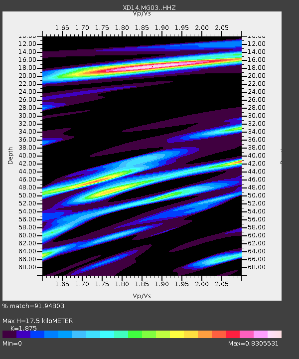
| Estimated Moho Depth: |
17.5 km |
| Estimated Crust Vp/Vs: |
1.88 |
| Assumed Crust Vp: |
6.566 km/s |
| Estimated Crust Vs: |
3.502 km/s |
| Estimated Crust Poisson's Ratio: |
0.30 |
|
| Radial Match: |
91.94803 % |
| Radial Bump: |
385 |
| Transverse Match: |
83.63075 % |
| Transverse Bump: |
400 |
| SOD ConfigId: |
3390531 |
| Insert Time: |
2019-04-12 23:11:14.715 +0000 |
| GWidth: |
2.5 |
| Max Bumps: |
400 |
| Tol: |
0.001 |
|

Signal To Noise
| Channel | StoN | STA | LTA |
| XD:MG03: :HHZ:20140719T12:38:09.629985Z | 12.09404 | 8.3213143E-7 | 6.880508E-8 |
| XD:MG03: :HHN:20140719T12:38:09.629985Z | 2.7098691 | 1.7731367E-7 | 6.543255E-8 |
| XD:MG03: :HHE:20140719T12:38:09.629985Z | 4.315726 | 3.1424037E-7 | 7.281287E-8 |
| Arrivals |
| Ps | 2.4 SECOND |
| PpPs | 7.4 SECOND |
| PsPs/PpSs | 9.8 SECOND |


