You are here: Home > Network List > XD14 - Illuminating the architecture of the greater Mount St. Helens magmatic systems f Stations List
> Station MH11 "Mount St Helens, WA" > Earthquake Result Viewer
MH11 "Mount St Helens, WA" - Earthquake Result Viewer
| Earthquake location: |
Tonga Islands |
| Earthquake latitude/longitude: |
-15.8/-174.4 |
| Earthquake time(UTC): |
2014/07/19 (200) 12:27:09 GMT |
| Earthquake Depth: |
220 km |
| Earthquake Magnitude: |
6.0 MWP |
| Earthquake Catalog/Contributor: |
NEIC PDE/NEIC COMCAT |
|
| Network: |
XD Illuminating the architecture of the greater Mount St. Helens magmatic systems f |
| Station: |
MH11 "Mount St Helens, WA" |
| Lat/Lon: |
46.27 N/121.58 W |
| Elevation: |
1447 m |
|
| Distance: |
78.0 deg |
| Az: |
34.413 deg |
| Baz: |
231.659 deg |
| Ray Param: |
0.049400304 |
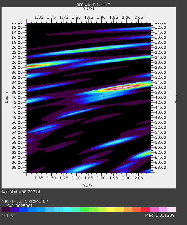
| Estimated Moho Depth: |
35.75 km |
| Estimated Crust Vp/Vs: |
1.98 |
| Assumed Crust Vp: |
6.597 km/s |
| Estimated Crust Vs: |
3.328 km/s |
| Estimated Crust Poisson's Ratio: |
0.33 |
|
| Radial Match: |
88.29716 % |
| Radial Bump: |
400 |
| Transverse Match: |
79.06193 % |
| Transverse Bump: |
400 |
| SOD ConfigId: |
3390531 |
| Insert Time: |
2019-04-12 23:11:20.955 +0000 |
| GWidth: |
2.5 |
| Max Bumps: |
400 |
| Tol: |
0.001 |
|

Signal To Noise
| Channel | StoN | STA | LTA |
| XD:MH11: :HHZ:20140719T12:38:12.064983Z | 10.7734165 | 8.638851E-7 | 8.018674E-8 |
| XD:MH11: :HHN:20140719T12:38:12.064983Z | 2.4405851 | 3.2963385E-7 | 1.3506346E-7 |
| XD:MH11: :HHE:20140719T12:38:12.064983Z | 4.7868013 | 4.838028E-7 | 1.0107017E-7 |
| Arrivals |
| Ps | 5.5 SECOND |
| PpPs | 16 SECOND |
| PsPs/PpSs | 21 SECOND |


