You are here: Home > Network List > XD14 - Illuminating the architecture of the greater Mount St. Helens magmatic systems f Stations List
> Station MJ02 "Mount St Helens, WA" > Earthquake Result Viewer
MJ02 "Mount St Helens, WA" - Earthquake Result Viewer
| Earthquake location: |
Tonga Islands |
| Earthquake latitude/longitude: |
-15.8/-174.4 |
| Earthquake time(UTC): |
2014/07/19 (200) 12:27:09 GMT |
| Earthquake Depth: |
220 km |
| Earthquake Magnitude: |
6.0 MWP |
| Earthquake Catalog/Contributor: |
NEIC PDE/NEIC COMCAT |
|
| Network: |
XD Illuminating the architecture of the greater Mount St. Helens magmatic systems f |
| Station: |
MJ02 "Mount St Helens, WA" |
| Lat/Lon: |
46.14 N/122.70 W |
| Elevation: |
317 m |
|
| Distance: |
77.3 deg |
| Az: |
34.018 deg |
| Baz: |
230.767 deg |
| Ray Param: |
0.049863216 |
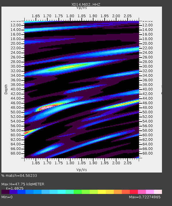
| Estimated Moho Depth: |
47.75 km |
| Estimated Crust Vp/Vs: |
1.69 |
| Assumed Crust Vp: |
6.566 km/s |
| Estimated Crust Vs: |
3.88 km/s |
| Estimated Crust Poisson's Ratio: |
0.23 |
|
| Radial Match: |
84.58233 % |
| Radial Bump: |
289 |
| Transverse Match: |
83.84552 % |
| Transverse Bump: |
325 |
| SOD ConfigId: |
3390531 |
| Insert Time: |
2019-04-12 23:11:27.381 +0000 |
| GWidth: |
2.5 |
| Max Bumps: |
400 |
| Tol: |
0.001 |
|

Signal To Noise
| Channel | StoN | STA | LTA |
| XD:MJ02: :HHZ:20140719T12:38:08.270Z | 10.192956 | 8.4419145E-7 | 8.282106E-8 |
| XD:MJ02: :HHN:20140719T12:38:08.270Z | 1.9727366 | 2.234811E-7 | 1.1328482E-7 |
| XD:MJ02: :HHE:20140719T12:38:08.270Z | 2.2256238 | 2.3079356E-7 | 1.0369836E-7 |
| Arrivals |
| Ps | 5.2 SECOND |
| PpPs | 19 SECOND |
| PsPs/PpSs | 24 SECOND |


