You are here: Home > Network List > XD14 - Illuminating the architecture of the greater Mount St. Helens magmatic systems f Stations List
> Station MK06 "Mount St Helens, WA" > Earthquake Result Viewer
MK06 "Mount St Helens, WA" - Earthquake Result Viewer
| Earthquake location: |
Tonga Islands |
| Earthquake latitude/longitude: |
-15.8/-174.4 |
| Earthquake time(UTC): |
2014/07/19 (200) 12:27:09 GMT |
| Earthquake Depth: |
220 km |
| Earthquake Magnitude: |
6.0 MWP |
| Earthquake Catalog/Contributor: |
NEIC PDE/NEIC COMCAT |
|
| Network: |
XD Illuminating the architecture of the greater Mount St. Helens magmatic systems f |
| Station: |
MK06 "Mount St Helens, WA" |
| Lat/Lon: |
46.12 N/122.19 W |
| Elevation: |
680 m |
|
| Distance: |
77.5 deg |
| Az: |
34.263 deg |
| Baz: |
231.186 deg |
| Ray Param: |
0.04968718 |
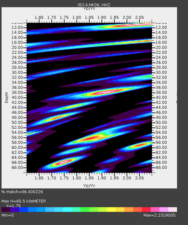
| Estimated Moho Depth: |
65.5 km |
| Estimated Crust Vp/Vs: |
1.75 |
| Assumed Crust Vp: |
6.566 km/s |
| Estimated Crust Vs: |
3.752 km/s |
| Estimated Crust Poisson's Ratio: |
0.26 |
|
| Radial Match: |
86.408226 % |
| Radial Bump: |
400 |
| Transverse Match: |
83.56004 % |
| Transverse Bump: |
400 |
| SOD ConfigId: |
3390531 |
| Insert Time: |
2019-04-12 23:11:32.018 +0000 |
| GWidth: |
2.5 |
| Max Bumps: |
400 |
| Tol: |
0.001 |
|

Signal To Noise
| Channel | StoN | STA | LTA |
| XD:MK06: :HHZ:20140719T12:38:09.720012Z | 14.368866 | 9.784633E-7 | 6.809607E-8 |
| XD:MK06: :HHN:20140719T12:38:09.720012Z | 3.1368465 | 4.847775E-7 | 1.5454295E-7 |
| XD:MK06: :HHE:20140719T12:38:09.720012Z | 2.4582806 | 3.2095195E-7 | 1.3055953E-7 |
| Arrivals |
| Ps | 7.7 SECOND |
| PpPs | 27 SECOND |
| PsPs/PpSs | 34 SECOND |


