You are here: Home > Network List > XD14 - Illuminating the architecture of the greater Mount St. Helens magmatic systems f Stations List
> Station ML03 "Mount St Helens, WA" > Earthquake Result Viewer
ML03 "Mount St Helens, WA" - Earthquake Result Viewer
| Earthquake location: |
Tonga Islands |
| Earthquake latitude/longitude: |
-15.8/-174.4 |
| Earthquake time(UTC): |
2014/07/19 (200) 12:27:09 GMT |
| Earthquake Depth: |
220 km |
| Earthquake Magnitude: |
6.0 MWP |
| Earthquake Catalog/Contributor: |
NEIC PDE/NEIC COMCAT |
|
| Network: |
XD Illuminating the architecture of the greater Mount St. Helens magmatic systems f |
| Station: |
ML03 "Mount St Helens, WA" |
| Lat/Lon: |
46.06 N/122.52 W |
| Elevation: |
356 m |
|
| Distance: |
77.3 deg |
| Az: |
34.162 deg |
| Baz: |
230.932 deg |
| Ray Param: |
0.049828466 |
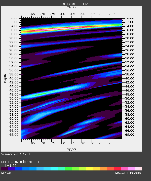
| Estimated Moho Depth: |
15.25 km |
| Estimated Crust Vp/Vs: |
1.77 |
| Assumed Crust Vp: |
6.566 km/s |
| Estimated Crust Vs: |
3.71 km/s |
| Estimated Crust Poisson's Ratio: |
0.27 |
|
| Radial Match: |
84.47015 % |
| Radial Bump: |
400 |
| Transverse Match: |
87.34165 % |
| Transverse Bump: |
342 |
| SOD ConfigId: |
3390531 |
| Insert Time: |
2019-04-12 23:11:36.009 +0000 |
| GWidth: |
2.5 |
| Max Bumps: |
400 |
| Tol: |
0.001 |
|

Signal To Noise
| Channel | StoN | STA | LTA |
| XD:ML03: :HHZ:20140719T12:38:08.559978Z | 11.50537 | 8.447464E-7 | 7.342192E-8 |
| XD:ML03: :HHN:20140719T12:38:08.559978Z | 2.6055126 | 3.0889953E-7 | 1.1855615E-7 |
| XD:ML03: :HHE:20140719T12:38:08.559978Z | 0.95292556 | 9.763083E-8 | 1.0245378E-7 |
| Arrivals |
| Ps | 1.8 SECOND |
| PpPs | 6.2 SECOND |
| PsPs/PpSs | 8.1 SECOND |


