You are here: Home > Network List > II - Global Seismograph Network (GSN - IRIS/IDA) Stations List
> Station WRAB Tennant Creek, NT, Australia > Earthquake Result Viewer
WRAB Tennant Creek, NT, Australia - Earthquake Result Viewer
*The percent match for this event was below the threshold and hence no stack was calculated.
| Earthquake location: |
Southwestern Ryukyu Isl., Japan |
| Earthquake latitude/longitude: |
24.9/123.4 |
| Earthquake time(UTC): |
2013/04/18 (108) 14:08:35 GMT |
| Earthquake Depth: |
10 km |
| Earthquake Magnitude: |
5.5 MW |
| Earthquake Catalog/Contributor: |
NEIC PDE/NEIC PDE-W |
|
| Network: |
II Global Seismograph Network (GSN - IRIS/IDA) |
| Station: |
WRAB Tennant Creek, NT, Australia |
| Lat/Lon: |
19.93 S/134.36 E |
| Elevation: |
366 m |
|
| Distance: |
45.9 deg |
| Az: |
165.507 deg |
| Baz: |
346.024 deg |
| Ray Param: |
$rayparam |
*The percent match for this event was below the threshold and hence was not used in the summary stack. |
|
| Radial Match: |
68.46926 % |
| Radial Bump: |
335 |
| Transverse Match: |
67.66753 % |
| Transverse Bump: |
400 |
| SOD ConfigId: |
512894 |
| Insert Time: |
2013-09-13 10:08:00.913 +0000 |
| GWidth: |
2.5 |
| Max Bumps: |
400 |
| Tol: |
0.001 |
|
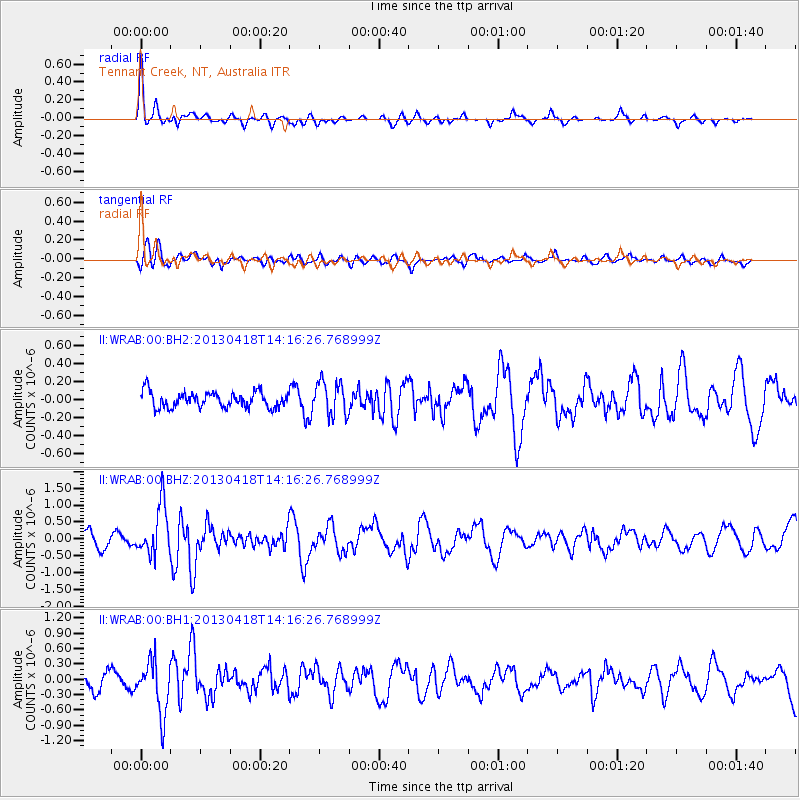
Signal To Noise
| Channel | StoN | STA | LTA |
| II:WRAB:00:BHZ:20130418T14:16:26.768999Z | 3.2254853 | 7.507066E-7 | 2.3274221E-7 |
| II:WRAB:00:BH1:20130418T14:16:26.768999Z | 3.4026408 | 5.188685E-7 | 1.5248995E-7 |
| II:WRAB:00:BH2:20130418T14:16:26.768999Z | 2.184523 | 1.8917142E-7 | 8.659621E-8 |
| Arrivals |
| Ps | |
| PpPs | |
| PsPs/PpSs | |


