You are here: Home > Network List > NI - North-East Italy Broadband Network Stations List
> Station CGRP Cima Grappa > Earthquake Result Viewer
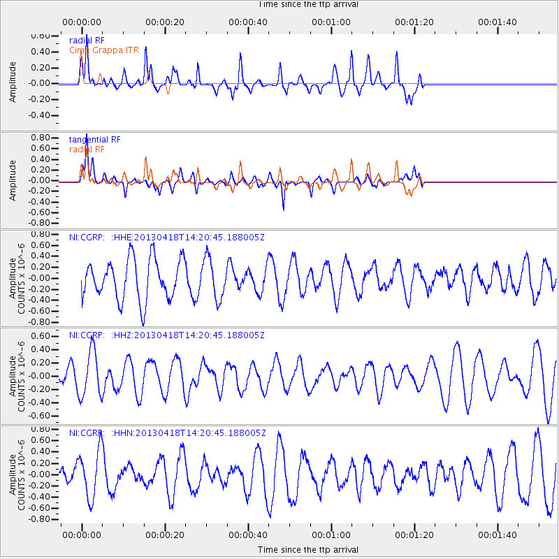
CGRP Cima Grappa - Earthquake Result Viewer
*The percent match for this event was below the threshold and hence no stack was calculated.
| Earthquake location: |
Southwestern Ryukyu Isl., Japan |
| Earthquake latitude/longitude: |
24.9/123.4 |
| Earthquake time(UTC): |
2013/04/18 (108) 14:08:35 GMT |
| Earthquake Depth: |
10 km |
| Earthquake Magnitude: |
5.5 MW |
| Earthquake Catalog/Contributor: |
NEIC PDE/NEIC PDE-W |
|
| Network: |
NI North-East Italy Broadband Network |
| Station: |
CGRP Cima Grappa |
| Lat/Lon: |
45.88 N/11.80 E |
| Elevation: |
1757 m |
|
| Distance: |
86.2 deg |
| Az: |
319.369 deg |
| Baz: |
57.818 deg |
| Ray Param: |
$rayparam |
*The percent match for this event was below the threshold and hence was not used in the summary stack. |
|
| Radial Match: |
67.52294 % |
| Radial Bump: |
320 |
| Transverse Match: |
76.46304 % |
| Transverse Bump: |
372 |
| SOD ConfigId: |
512894 |
| Insert Time: |
2013-09-13 10:11:03.090 +0000 |
| GWidth: |
2.5 |
| Max Bumps: |
400 |
| Tol: |
0.001 |
|
Signal To Noise
| Channel | StoN | STA | LTA |
| NI:CGRP: :HHZ:20130418T14:20:45.188005Z | 2.6924295 | 3.5085563E-7 | 1.303119E-7 |
| NI:CGRP: :HHN:20130418T14:20:45.188005Z | 2.2233217 | 4.2764563E-7 | 1.9234537E-7 |
| NI:CGRP: :HHE:20130418T14:20:45.188005Z | 1.0155371 | 3.7002363E-7 | 3.6436248E-7 |
| Arrivals |
| Ps | |
| PpPs | |
| PsPs/PpSs | |


