You are here: Home > Network List > TA - USArray Transportable Network (new EarthScope stations) Stations List
> Station H17A Grant Village (NPS), Yellowstone Nt. Park, WY, USA > Earthquake Result Viewer
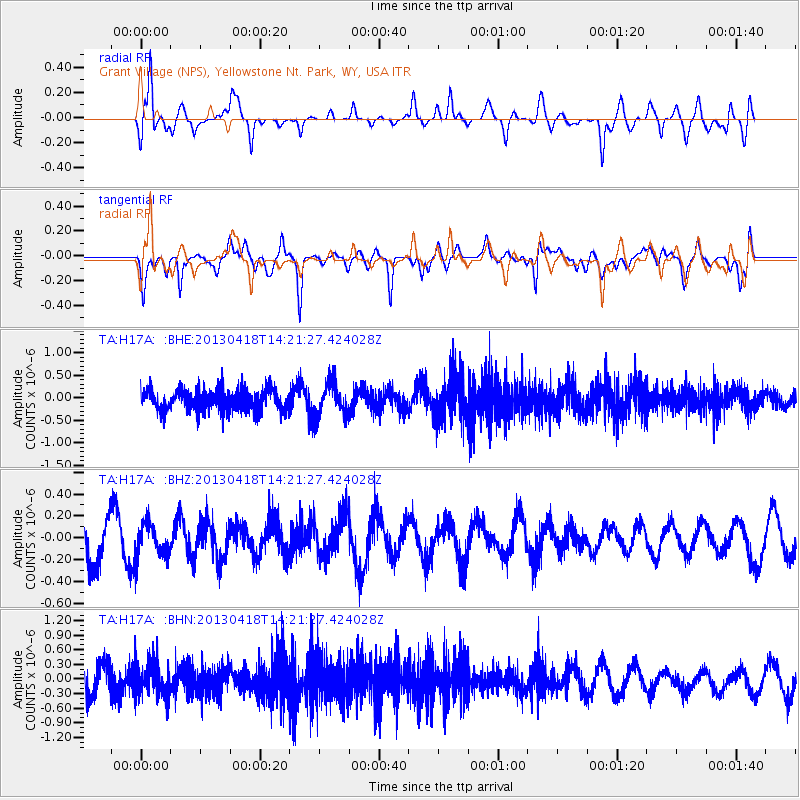
H17A Grant Village (NPS), Yellowstone Nt. Park, WY, USA - Earthquake Result Viewer
*The percent match for this event was below the threshold and hence no stack was calculated.
| Earthquake location: |
Southwestern Ryukyu Isl., Japan |
| Earthquake latitude/longitude: |
24.9/123.4 |
| Earthquake time(UTC): |
2013/04/18 (108) 14:08:35 GMT |
| Earthquake Depth: |
10 km |
| Earthquake Magnitude: |
5.5 MW |
| Earthquake Catalog/Contributor: |
NEIC PDE/NEIC PDE-W |
|
| Network: |
TA USArray Transportable Network (new EarthScope stations) |
| Station: |
H17A Grant Village (NPS), Yellowstone Nt. Park, WY, USA |
| Lat/Lon: |
44.40 N/110.58 W |
| Elevation: |
2400 m |
|
| Distance: |
95.2 deg |
| Az: |
35.583 deg |
| Baz: |
312.526 deg |
| Ray Param: |
$rayparam |
*The percent match for this event was below the threshold and hence was not used in the summary stack. |
|
| Radial Match: |
67.30881 % |
| Radial Bump: |
400 |
| Transverse Match: |
65.536156 % |
| Transverse Bump: |
400 |
| SOD ConfigId: |
512894 |
| Insert Time: |
2013-09-13 10:14:03.752 +0000 |
| GWidth: |
2.5 |
| Max Bumps: |
400 |
| Tol: |
0.001 |
|
Signal To Noise
| Channel | StoN | STA | LTA |
| TA:H17A: :BHZ:20130418T14:21:27.424028Z | 0.89398944 | 1.5242594E-7 | 1.7050081E-7 |
| TA:H17A: :BHN:20130418T14:21:27.424028Z | 1.3734037 | 3.623841E-7 | 2.638584E-7 |
| TA:H17A: :BHE:20130418T14:21:27.424028Z | 1.5385401 | 3.7649878E-7 | 2.447117E-7 |
| Arrivals |
| Ps | |
| PpPs | |
| PsPs/PpSs | |


