You are here: Home > Network List > TA - USArray Transportable Network (new EarthScope stations) Stations List
> Station R11A Troy Canyon, Currant, NV, USA > Earthquake Result Viewer
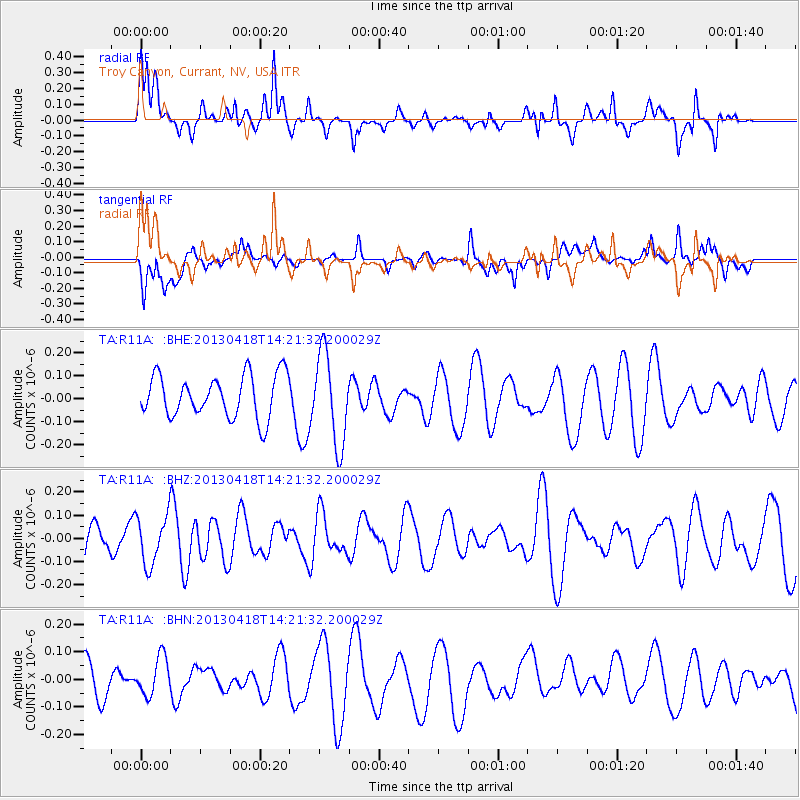
R11A Troy Canyon, Currant, NV, USA - Earthquake Result Viewer
*The percent match for this event was below the threshold and hence no stack was calculated.
| Earthquake location: |
Southwestern Ryukyu Isl., Japan |
| Earthquake latitude/longitude: |
24.9/123.4 |
| Earthquake time(UTC): |
2013/04/18 (108) 14:08:35 GMT |
| Earthquake Depth: |
10 km |
| Earthquake Magnitude: |
5.5 MW |
| Earthquake Catalog/Contributor: |
NEIC PDE/NEIC PDE-W |
|
| Network: |
TA USArray Transportable Network (new EarthScope stations) |
| Station: |
R11A Troy Canyon, Currant, NV, USA |
| Lat/Lon: |
38.35 N/115.59 W |
| Elevation: |
1756 m |
|
| Distance: |
96.3 deg |
| Az: |
42.657 deg |
| Baz: |
308.512 deg |
| Ray Param: |
$rayparam |
*The percent match for this event was below the threshold and hence was not used in the summary stack. |
|
| Radial Match: |
61.30998 % |
| Radial Bump: |
322 |
| Transverse Match: |
46.568428 % |
| Transverse Bump: |
400 |
| SOD ConfigId: |
512894 |
| Insert Time: |
2013-09-13 10:14:44.152 +0000 |
| GWidth: |
2.5 |
| Max Bumps: |
400 |
| Tol: |
0.001 |
|
Signal To Noise
| Channel | StoN | STA | LTA |
| TA:R11A: :BHZ:20130418T14:21:32.200029Z | 1.1045318 | 1.05147116E-7 | 9.519611E-8 |
| TA:R11A: :BHN:20130418T14:21:32.200029Z | 1.0655304 | 6.88733E-8 | 6.4637575E-8 |
| TA:R11A: :BHE:20130418T14:21:32.200029Z | 2.1543093 | 1.9742556E-7 | 9.164217E-8 |
| Arrivals |
| Ps | |
| PpPs | |
| PsPs/PpSs | |


