You are here: Home > Network List > TA - USArray Transportable Network (new EarthScope stations) Stations List
> Station K22A Casper, WY, USA > Earthquake Result Viewer
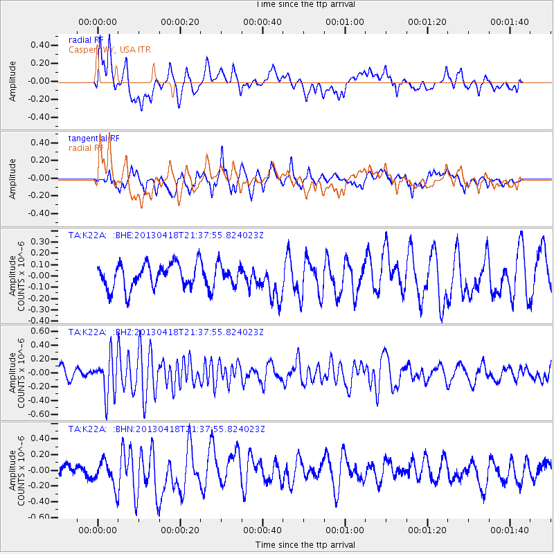
K22A Casper, WY, USA - Earthquake Result Viewer
*The percent match for this event was below the threshold and hence no stack was calculated.
| Earthquake location: |
Southern East Pacific Rise |
| Earthquake latitude/longitude: |
-34.3/-109.2 |
| Earthquake time(UTC): |
2013/04/18 (108) 21:26:36 GMT |
| Earthquake Depth: |
10 km |
| Earthquake Magnitude: |
5.5 MW |
| Earthquake Catalog/Contributor: |
NEIC PDE/NEIC PDE-W |
|
| Network: |
TA USArray Transportable Network (new EarthScope stations) |
| Station: |
K22A Casper, WY, USA |
| Lat/Lon: |
42.65 N/106.52 W |
| Elevation: |
1686 m |
|
| Distance: |
76.7 deg |
| Az: |
2.039 deg |
| Baz: |
182.286 deg |
| Ray Param: |
$rayparam |
*The percent match for this event was below the threshold and hence was not used in the summary stack. |
|
| Radial Match: |
47.60354 % |
| Radial Bump: |
400 |
| Transverse Match: |
58.0264 % |
| Transverse Bump: |
400 |
| SOD ConfigId: |
512894 |
| Insert Time: |
2013-09-13 10:40:32.781 +0000 |
| GWidth: |
2.5 |
| Max Bumps: |
400 |
| Tol: |
0.001 |
|
Signal To Noise
| Channel | StoN | STA | LTA |
| TA:K22A: :BHZ:20130418T21:37:55.824023Z | 3.684331 | 2.931112E-7 | 7.955616E-8 |
| TA:K22A: :BHN:20130418T21:37:55.824023Z | 1.093334 | 1.817854E-7 | 1.6626704E-7 |
| TA:K22A: :BHE:20130418T21:37:55.824023Z | 0.81370807 | 8.887823E-8 | 1.0922619E-7 |
| Arrivals |
| Ps | |
| PpPs | |
| PsPs/PpSs | |


