You are here: Home > Network List > US - United States National Seismic Network Stations List
> Station DUG Dugway, Tooele County, Utah, USA > Earthquake Result Viewer
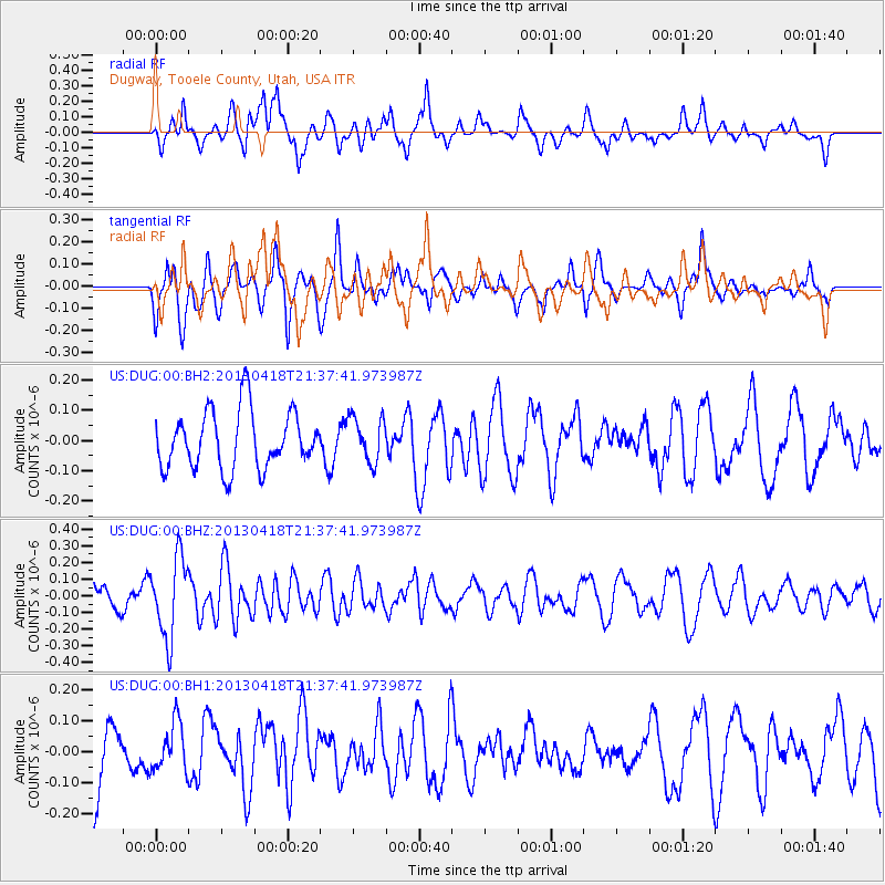
DUG Dugway, Tooele County, Utah, USA - Earthquake Result Viewer
*The percent match for this event was below the threshold and hence no stack was calculated.
| Earthquake location: |
Southern East Pacific Rise |
| Earthquake latitude/longitude: |
-34.3/-109.2 |
| Earthquake time(UTC): |
2013/04/18 (108) 21:26:36 GMT |
| Earthquake Depth: |
10 km |
| Earthquake Magnitude: |
5.5 MW |
| Earthquake Catalog/Contributor: |
NEIC PDE/NEIC PDE-W |
|
| Network: |
US United States National Seismic Network |
| Station: |
DUG Dugway, Tooele County, Utah, USA |
| Lat/Lon: |
40.19 N/112.81 W |
| Elevation: |
1477 m |
|
| Distance: |
74.2 deg |
| Az: |
357.135 deg |
| Baz: |
176.905 deg |
| Ray Param: |
$rayparam |
*The percent match for this event was below the threshold and hence was not used in the summary stack. |
|
| Radial Match: |
67.2011 % |
| Radial Bump: |
400 |
| Transverse Match: |
61.461018 % |
| Transverse Bump: |
400 |
| SOD ConfigId: |
512894 |
| Insert Time: |
2013-09-13 10:50:51.774 +0000 |
| GWidth: |
2.5 |
| Max Bumps: |
400 |
| Tol: |
0.001 |
|
Signal To Noise
| Channel | StoN | STA | LTA |
| US:DUG:00:BHZ:20130418T21:37:41.973987Z | 3.256377 | 2.3764274E-7 | 7.2977656E-8 |
| US:DUG:00:BH1:20130418T21:37:41.973987Z | 0.7322514 | 7.694408E-8 | 1.0507878E-7 |
| US:DUG:00:BH2:20130418T21:37:41.973987Z | 0.7811023 | 7.427921E-8 | 9.5095366E-8 |
| Arrivals |
| Ps | |
| PpPs | |
| PsPs/PpSs | |


