You are here: Home > Network List > WY - Yellowstone Wyoming Seismic Network Stations List
> Station YHH Holmes Hill, YNP, WY, USA > Earthquake Result Viewer
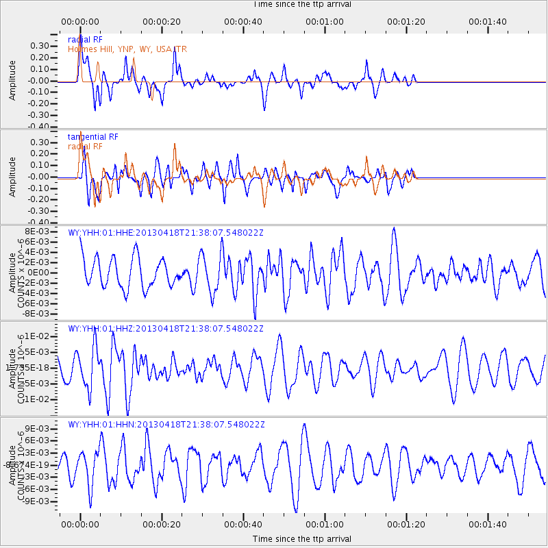
YHH Holmes Hill, YNP, WY, USA - Earthquake Result Viewer
*The percent match for this event was below the threshold and hence no stack was calculated.
| Earthquake location: |
Southern East Pacific Rise |
| Earthquake latitude/longitude: |
-34.3/-109.2 |
| Earthquake time(UTC): |
2013/04/18 (108) 21:26:36 GMT |
| Earthquake Depth: |
10 km |
| Earthquake Magnitude: |
5.5 MW |
| Earthquake Catalog/Contributor: |
NEIC PDE/NEIC PDE-W |
|
| Network: |
WY Yellowstone Wyoming Seismic Network |
| Station: |
YHH Holmes Hill, YNP, WY, USA |
| Lat/Lon: |
44.79 N/110.85 W |
| Elevation: |
2717 m |
|
| Distance: |
78.8 deg |
| Az: |
358.811 deg |
| Baz: |
178.619 deg |
| Ray Param: |
$rayparam |
*The percent match for this event was below the threshold and hence was not used in the summary stack. |
|
| Radial Match: |
68.440796 % |
| Radial Bump: |
395 |
| Transverse Match: |
62.91632 % |
| Transverse Bump: |
400 |
| SOD ConfigId: |
512894 |
| Insert Time: |
2013-09-13 10:55:00.078 +0000 |
| GWidth: |
2.5 |
| Max Bumps: |
400 |
| Tol: |
0.001 |
|
Signal To Noise
| Channel | StoN | STA | LTA |
| WY:YHH:01:HHZ:20130418T21:38:07.548022Z | 2.2021034 | 6.5703847E-9 | 2.983686E-9 |
| WY:YHH:01:HHN:20130418T21:38:07.548022Z | 1.802113 | 4.2289856E-9 | 2.3466815E-9 |
| WY:YHH:01:HHE:20130418T21:38:07.548022Z | 1.3339221 | 3.764832E-9 | 2.8223774E-9 |
| Arrivals |
| Ps | |
| PpPs | |
| PsPs/PpSs | |


