You are here: Home > Network List > AG - Arkansas Seismic Network Stations List
> Station FCAR Ozark Folk Center,AR > Earthquake Result Viewer
FCAR Ozark Folk Center,AR - Earthquake Result Viewer
| Earthquake location: |
Kuril Islands |
| Earthquake latitude/longitude: |
46.2/150.8 |
| Earthquake time(UTC): |
2013/04/19 (109) 03:05:52 GMT |
| Earthquake Depth: |
110 km |
| Earthquake Magnitude: |
7.2 MW, 7.1 MB, 7.2 MW |
| Earthquake Catalog/Contributor: |
NEIC PDE/NEIC PDE-W |
|
| Network: |
AG Arkansas Seismic Network |
| Station: |
FCAR Ozark Folk Center,AR |
| Lat/Lon: |
35.89 N/92.12 W |
| Elevation: |
190 m |
|
| Distance: |
80.6 deg |
| Az: |
47.12 deg |
| Baz: |
321.204 deg |
| Ray Param: |
0.04792264 |
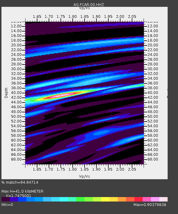
| Estimated Moho Depth: |
41.0 km |
| Estimated Crust Vp/Vs: |
1.75 |
| Assumed Crust Vp: |
6.498 km/s |
| Estimated Crust Vs: |
3.718 km/s |
| Estimated Crust Poisson's Ratio: |
0.26 |
|
| Radial Match: |
94.94714 % |
| Radial Bump: |
348 |
| Transverse Match: |
60.191875 % |
| Transverse Bump: |
400 |
| SOD ConfigId: |
512894 |
| Insert Time: |
2013-09-13 10:57:04.645 +0000 |
| GWidth: |
2.5 |
| Max Bumps: |
400 |
| Tol: |
0.001 |
|

Signal To Noise
| Channel | StoN | STA | LTA |
| AG:FCAR:00:HHZ:20130419T03:17:22.009985Z | 31.43937 | 5.001272E-6 | 1.5907672E-7 |
| AG:FCAR:00:HHN:20130419T03:17:22.009985Z | 1.6262262 | 1.374418E-6 | 8.45158E-7 |
| AG:FCAR:00:HHE:20130419T03:17:22.009985Z | 2.0837836 | 1.8247541E-6 | 8.756927E-7 |
| Arrivals |
| Ps | 4.9 SECOND |
| PpPs | 17 SECOND |
| PsPs/PpSs | 22 SECOND |


