You are here: Home > Network List > AG - Arkansas Seismic Network Stations List
> Station WLAR White Oak Lake,AR > Earthquake Result Viewer
WLAR White Oak Lake,AR - Earthquake Result Viewer

| Earthquake location: |
Kuril Islands |
| Earthquake latitude/longitude: |
46.2/150.8 |
| Earthquake time(UTC): |
2013/04/19 (109) 03:05:52 GMT |
| Earthquake Depth: |
110 km |
| Earthquake Magnitude: |
7.2 MW, 7.1 MB, 7.2 MW |
| Earthquake Catalog/Contributor: |
NEIC PDE/NEIC PDE-W |
|
| Network: |
AG Arkansas Seismic Network |
| Station: |
WLAR White Oak Lake,AR |
| Lat/Lon: |
33.69 N/93.11 W |
| Elevation: |
77 m |
|
| Distance: |
81.8 deg |
| Az: |
49.156 deg |
| Baz: |
320.954 deg |
| Ray Param: |
0.047086265 |
| Estimated Moho Depth: |
24.5 km |
| Estimated Crust Vp/Vs: |
2.01 |
| Assumed Crust Vp: |
6.245 km/s |
| Estimated Crust Vs: |
3.103 km/s |
| Estimated Crust Poisson's Ratio: |
0.34 |
|
| Radial Match: |
87.45683 % |
| Radial Bump: |
400 |
| Transverse Match: |
76.600746 % |
| Transverse Bump: |
400 |
| SOD ConfigId: |
512894 |
| Insert Time: |
2013-09-13 10:57:16.988 +0000 |
| GWidth: |
2.5 |
| Max Bumps: |
400 |
| Tol: |
0.001 |
|
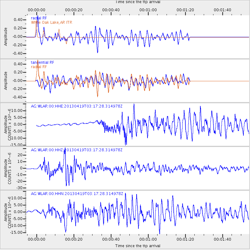
Signal To Noise
| Channel | StoN | STA | LTA |
| AG:WLAR:00:HHZ:20130419T03:17:28.314978Z | 23.485695 | 5.1949696E-6 | 2.2119718E-7 |
| AG:WLAR:00:HHN:20130419T03:17:28.314978Z | 3.8255322 | 1.3991273E-6 | 3.6573405E-7 |
| AG:WLAR:00:HHE:20130419T03:17:28.314978Z | 3.178655 | 1.8943489E-6 | 5.9595925E-7 |
| Arrivals |
| Ps | 4.1 SECOND |
| PpPs | 12 SECOND |
| PsPs/PpSs | 16 SECOND |


