You are here: Home > Network List > AT - Alaska Tsunami Warning Seismic System Stations List
> Station CRAG Craig, Alaska > Earthquake Result Viewer
CRAG Craig, Alaska - Earthquake Result Viewer
| Earthquake location: |
Kuril Islands |
| Earthquake latitude/longitude: |
46.2/150.8 |
| Earthquake time(UTC): |
2013/04/19 (109) 03:05:52 GMT |
| Earthquake Depth: |
110 km |
| Earthquake Magnitude: |
7.2 MW, 7.1 MB, 7.2 MW |
| Earthquake Catalog/Contributor: |
NEIC PDE/NEIC PDE-W |
|
| Network: |
AT Alaska Tsunami Warning Seismic System |
| Station: |
CRAG Craig, Alaska |
| Lat/Lon: |
55.47 N/133.12 W |
| Elevation: |
58 m |
|
| Distance: |
46.6 deg |
| Az: |
49.492 deg |
| Baz: |
292.023 deg |
| Ray Param: |
0.070136316 |
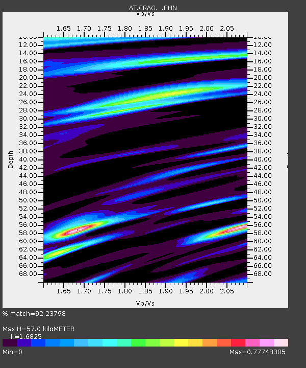
| Estimated Moho Depth: |
57.0 km |
| Estimated Crust Vp/Vs: |
1.68 |
| Assumed Crust Vp: |
6.472 km/s |
| Estimated Crust Vs: |
3.847 km/s |
| Estimated Crust Poisson's Ratio: |
0.23 |
|
| Radial Match: |
92.23798 % |
| Radial Bump: |
369 |
| Transverse Match: |
87.08667 % |
| Transverse Bump: |
400 |
| SOD ConfigId: |
512894 |
| Insert Time: |
2013-09-13 11:00:29.054 +0000 |
| GWidth: |
2.5 |
| Max Bumps: |
400 |
| Tol: |
0.001 |
|

Signal To Noise
| Channel | StoN | STA | LTA |
| AT:CRAG: :BHZ:20130419T03:13:39.419989Z | 12.7090025 | 3.748616E-6 | 2.9495754E-7 |
| AT:CRAG: :BHN:20130419T03:13:39.419989Z | 0.79936135 | 2.0715477E-7 | 2.5915034E-7 |
| AT:CRAG: :BHE:20130419T03:13:39.419989Z | 5.13712 | 1.6977096E-6 | 3.304789E-7 |
| Arrivals |
| Ps | 6.4 SECOND |
| PpPs | 22 SECOND |
| PsPs/PpSs | 29 SECOND |


