You are here: Home > Network List > AZ - ANZA Regional Network Stations List
> Station RDM AZ.RDM > Earthquake Result Viewer
RDM AZ.RDM - Earthquake Result Viewer
| Earthquake location: |
Kuril Islands |
| Earthquake latitude/longitude: |
46.2/150.8 |
| Earthquake time(UTC): |
2013/04/19 (109) 03:05:52 GMT |
| Earthquake Depth: |
110 km |
| Earthquake Magnitude: |
7.2 MW, 7.1 MB, 7.2 MW |
| Earthquake Catalog/Contributor: |
NEIC PDE/NEIC PDE-W |
|
| Network: |
AZ ANZA Regional Network |
| Station: |
RDM AZ.RDM |
| Lat/Lon: |
33.63 N/116.85 W |
| Elevation: |
1365 m |
|
| Distance: |
68.1 deg |
| Az: |
63.949 deg |
| Baz: |
311.616 deg |
| Ray Param: |
0.056233548 |
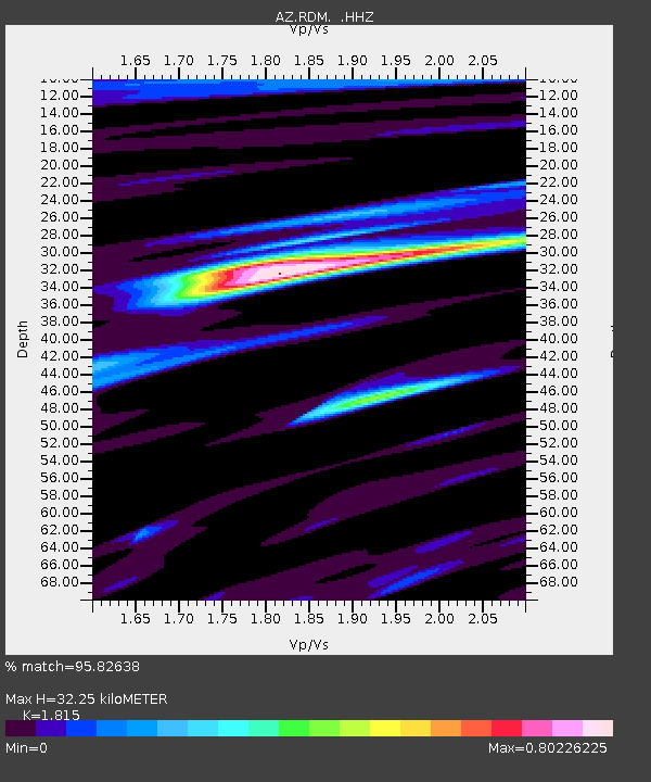
| Estimated Moho Depth: |
32.25 km |
| Estimated Crust Vp/Vs: |
1.82 |
| Assumed Crust Vp: |
6.264 km/s |
| Estimated Crust Vs: |
3.451 km/s |
| Estimated Crust Poisson's Ratio: |
0.28 |
|
| Radial Match: |
95.82638 % |
| Radial Bump: |
299 |
| Transverse Match: |
86.56941 % |
| Transverse Bump: |
388 |
| SOD ConfigId: |
512894 |
| Insert Time: |
2013-09-13 11:03:39.659 +0000 |
| GWidth: |
2.5 |
| Max Bumps: |
400 |
| Tol: |
0.001 |
|

Signal To Noise
| Channel | StoN | STA | LTA |
| AZ:RDM: :HHZ:20130419T03:16:09.868018Z | 19.830015 | 3.3908525E-6 | 1.7099597E-7 |
| AZ:RDM: :HHN:20130419T03:16:09.868018Z | 8.643617 | 1.1912434E-6 | 1.3781771E-7 |
| AZ:RDM: :HHE:20130419T03:16:09.868018Z | 11.972659 | 1.0271708E-6 | 8.579304E-8 |
| Arrivals |
| Ps | 4.3 SECOND |
| PpPs | 14 SECOND |
| PsPs/PpSs | 18 SECOND |


