You are here: Home > Network List > TA - USArray Transportable Network (new EarthScope stations) Stations List
> Station W60A Pink Hill, NC, USA > Earthquake Result Viewer
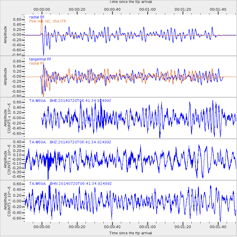
W60A Pink Hill, NC, USA - Earthquake Result Viewer
*The percent match for this event was below the threshold and hence no stack was calculated.
| Earthquake location: |
Central Chile |
| Earthquake latitude/longitude: |
-28.1/-70.8 |
| Earthquake time(UTC): |
2014/07/20 (201) 06:31:45 GMT |
| Earthquake Depth: |
70 km |
| Earthquake Magnitude: |
4.6 mb, 4.8 ML |
| Earthquake Catalog/Contributor: |
ISC/ISC |
|
| Network: |
TA USArray Transportable Network (new EarthScope stations) |
| Station: |
W60A Pink Hill, NC, USA |
| Lat/Lon: |
35.05 N/77.71 W |
| Elevation: |
30 m |
|
| Distance: |
63.1 deg |
| Az: |
353.667 deg |
| Baz: |
173.177 deg |
| Ray Param: |
$rayparam |
*The percent match for this event was below the threshold and hence was not used in the summary stack. |
|
| Radial Match: |
59.8251 % |
| Radial Bump: |
400 |
| Transverse Match: |
60.11794 % |
| Transverse Bump: |
400 |
| SOD ConfigId: |
3390531 |
| Insert Time: |
2019-04-12 23:27:41.893 +0000 |
| GWidth: |
2.5 |
| Max Bumps: |
400 |
| Tol: |
0.001 |
|
Signal To Noise
| Channel | StoN | STA | LTA |
| TA:W60A: :BHZ:20140720T06:41:34.92499Z | 0.785606 | 1.2105957E-7 | 1.5409705E-7 |
| TA:W60A: :BHN:20140720T06:41:34.92499Z | 1.0594454 | 2.3002177E-7 | 2.1711527E-7 |
| TA:W60A: :BHE:20140720T06:41:34.92499Z | 1.5018227 | 3.1405546E-7 | 2.0911621E-7 |
| Arrivals |
| Ps | |
| PpPs | |
| PsPs/PpSs | |


