You are here: Home > Network List > CN - Canadian National Seismograph Network Stations List
> Station A61 SAINTE MATHILDE, QC > Earthquake Result Viewer
A61 SAINTE MATHILDE, QC - Earthquake Result Viewer
| Earthquake location: |
Kuril Islands |
| Earthquake latitude/longitude: |
46.2/150.8 |
| Earthquake time(UTC): |
2013/04/19 (109) 03:05:52 GMT |
| Earthquake Depth: |
110 km |
| Earthquake Magnitude: |
7.2 MW, 7.1 MB, 7.2 MW |
| Earthquake Catalog/Contributor: |
NEIC PDE/NEIC PDE-W |
|
| Network: |
CN Canadian National Seismograph Network |
| Station: |
A61 SAINTE MATHILDE, QC |
| Lat/Lon: |
47.69 N/70.09 W |
| Elevation: |
393 m |
|
| Distance: |
79.9 deg |
| Az: |
26.689 deg |
| Baz: |
332.51 deg |
| Ray Param: |
0.04842 |
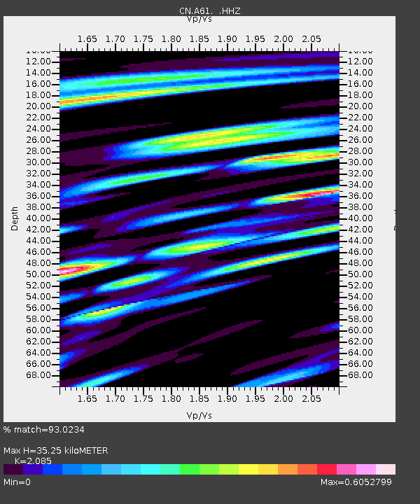
| Estimated Moho Depth: |
35.25 km |
| Estimated Crust Vp/Vs: |
2.09 |
| Assumed Crust Vp: |
6.61 km/s |
| Estimated Crust Vs: |
3.17 km/s |
| Estimated Crust Poisson's Ratio: |
0.35 |
|
| Radial Match: |
93.0234 % |
| Radial Bump: |
400 |
| Transverse Match: |
89.59046 % |
| Transverse Bump: |
400 |
| SOD ConfigId: |
512894 |
| Insert Time: |
2013-09-13 11:08:00.755 +0000 |
| GWidth: |
2.5 |
| Max Bumps: |
400 |
| Tol: |
0.001 |
|

Signal To Noise
| Channel | StoN | STA | LTA |
| CN:A61: :HHZ:20130419T03:17:18.069983Z | 25.473455 | 4.599722E-6 | 1.8056923E-7 |
| CN:A61: :HHN:20130419T03:17:18.069983Z | 4.931435 | 1.3212521E-6 | 2.6792446E-7 |
| CN:A61: :HHE:20130419T03:17:18.069983Z | 4.2392955 | 7.109224E-7 | 1.6769823E-7 |
| Arrivals |
| Ps | 5.9 SECOND |
| PpPs | 16 SECOND |
| PsPs/PpSs | 22 SECOND |


