You are here: Home > Network List > CN - Canadian National Seismograph Network Stations List
> Station ATKO ATIKOKAN IRON MINE, ON > Earthquake Result Viewer
ATKO ATIKOKAN IRON MINE, ON - Earthquake Result Viewer
| Earthquake location: |
Kuril Islands |
| Earthquake latitude/longitude: |
46.2/150.8 |
| Earthquake time(UTC): |
2013/04/19 (109) 03:05:52 GMT |
| Earthquake Depth: |
110 km |
| Earthquake Magnitude: |
7.2 MW, 7.1 MB, 7.2 MW |
| Earthquake Catalog/Contributor: |
NEIC PDE/NEIC PDE-W |
|
| Network: |
CN Canadian National Seismograph Network |
| Station: |
ATKO ATIKOKAN IRON MINE, ON |
| Lat/Lon: |
48.82 N/91.60 W |
| Elevation: |
383 m |
|
| Distance: |
70.9 deg |
| Az: |
38.301 deg |
| Baz: |
319.374 deg |
| Ray Param: |
0.05441746 |
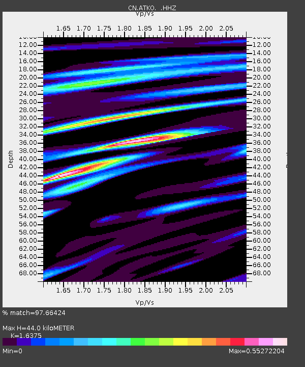
| Estimated Moho Depth: |
44.0 km |
| Estimated Crust Vp/Vs: |
1.64 |
| Assumed Crust Vp: |
6.467 km/s |
| Estimated Crust Vs: |
3.949 km/s |
| Estimated Crust Poisson's Ratio: |
0.20 |
|
| Radial Match: |
97.66424 % |
| Radial Bump: |
213 |
| Transverse Match: |
89.7851 % |
| Transverse Bump: |
400 |
| SOD ConfigId: |
512894 |
| Insert Time: |
2013-09-13 11:08:05.112 +0000 |
| GWidth: |
2.5 |
| Max Bumps: |
400 |
| Tol: |
0.001 |
|

Signal To Noise
| Channel | StoN | STA | LTA |
| CN:ATKO: :HHZ:20130419T03:16:26.88999Z | 33.338764 | 1.9392587E-6 | 5.816829E-8 |
| CN:ATKO: :HHN:20130419T03:16:26.88999Z | 16.084608 | 7.8454707E-7 | 4.877626E-8 |
| CN:ATKO: :HHE:20130419T03:16:26.88999Z | 10.229266 | 6.367266E-7 | 6.2245576E-8 |
| Arrivals |
| Ps | 4.5 SECOND |
| PpPs | 17 SECOND |
| PsPs/PpSs | 22 SECOND |


