You are here: Home > Network List > CN - Canadian National Seismograph Network Stations List
> Station LMQ LA MALBAIE, QC > Earthquake Result Viewer
LMQ LA MALBAIE, QC - Earthquake Result Viewer
| Earthquake location: |
Kuril Islands |
| Earthquake latitude/longitude: |
46.2/150.8 |
| Earthquake time(UTC): |
2013/04/19 (109) 03:05:52 GMT |
| Earthquake Depth: |
110 km |
| Earthquake Magnitude: |
7.2 MW, 7.1 MB, 7.2 MW |
| Earthquake Catalog/Contributor: |
NEIC PDE/NEIC PDE-W |
|
| Network: |
CN Canadian National Seismograph Network |
| Station: |
LMQ LA MALBAIE, QC |
| Lat/Lon: |
47.55 N/70.33 W |
| Elevation: |
429 m |
|
| Distance: |
79.9 deg |
| Az: |
26.9 deg |
| Baz: |
332.374 deg |
| Ray Param: |
0.048382435 |
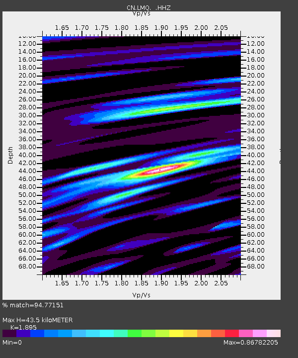
| Estimated Moho Depth: |
43.5 km |
| Estimated Crust Vp/Vs: |
1.89 |
| Assumed Crust Vp: |
6.61 km/s |
| Estimated Crust Vs: |
3.488 km/s |
| Estimated Crust Poisson's Ratio: |
0.31 |
|
| Radial Match: |
94.77151 % |
| Radial Bump: |
379 |
| Transverse Match: |
85.6414 % |
| Transverse Bump: |
400 |
| SOD ConfigId: |
512894 |
| Insert Time: |
2013-09-13 11:08:51.546 +0000 |
| GWidth: |
2.5 |
| Max Bumps: |
400 |
| Tol: |
0.001 |
|

Signal To Noise
| Channel | StoN | STA | LTA |
| CN:LMQ: :HHZ:20130419T03:17:18.369971Z | 19.38428 | 5.090075E-6 | 2.6258778E-7 |
| CN:LMQ: :HHN:20130419T03:17:18.369971Z | 5.5140905 | 1.5086711E-6 | 2.736029E-7 |
| CN:LMQ: :HHE:20130419T03:17:18.369971Z | 5.048509 | 1.0439178E-6 | 2.0677746E-7 |
| Arrivals |
| Ps | 6.1 SECOND |
| PpPs | 19 SECOND |
| PsPs/PpSs | 25 SECOND |


