You are here: Home > Network List > CN - Canadian National Seismograph Network Stations List
> Station YKW1 YKW1, NT, CANADA., CANADA > Earthquake Result Viewer
YKW1 YKW1, NT, CANADA., CANADA - Earthquake Result Viewer
| Earthquake location: |
Kuril Islands |
| Earthquake latitude/longitude: |
46.2/150.8 |
| Earthquake time(UTC): |
2013/04/19 (109) 03:05:52 GMT |
| Earthquake Depth: |
110 km |
| Earthquake Magnitude: |
7.2 MW, 7.1 MB, 7.2 MW |
| Earthquake Catalog/Contributor: |
NEIC PDE/NEIC PDE-W |
|
| Network: |
CN Canadian National Seismograph Network |
| Station: |
YKW1 YKW1, NT, CANADA., CANADA |
| Lat/Lon: |
62.48 N/114.48 W |
| Elevation: |
171 m |
|
| Distance: |
52.4 deg |
| Az: |
35.774 deg |
| Baz: |
299.089 deg |
| Ray Param: |
0.06646308 |
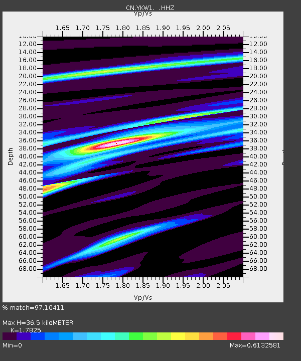
| Estimated Moho Depth: |
36.5 km |
| Estimated Crust Vp/Vs: |
1.78 |
| Assumed Crust Vp: |
6.459 km/s |
| Estimated Crust Vs: |
3.624 km/s |
| Estimated Crust Poisson's Ratio: |
0.27 |
|
| Radial Match: |
97.10411 % |
| Radial Bump: |
230 |
| Transverse Match: |
85.605194 % |
| Transverse Bump: |
400 |
| SOD ConfigId: |
512894 |
| Insert Time: |
2013-09-13 11:09:53.428 +0000 |
| GWidth: |
2.5 |
| Max Bumps: |
400 |
| Tol: |
0.001 |
|
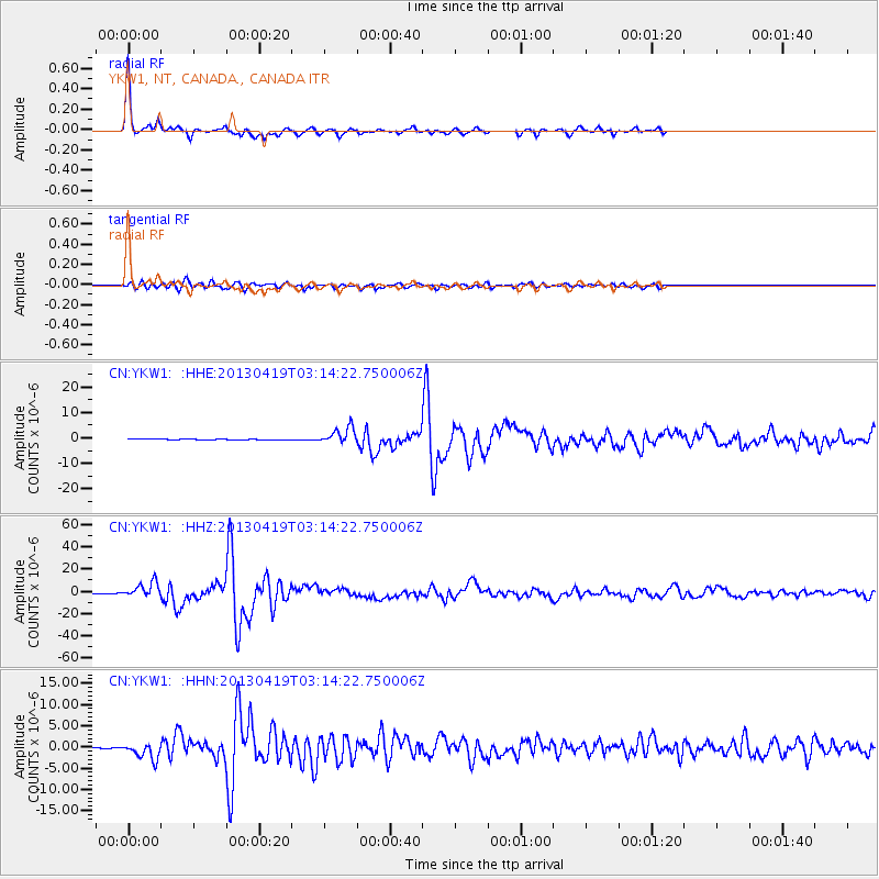
Signal To Noise
| Channel | StoN | STA | LTA |
| CN:YKW1: :HHZ:20130419T03:14:22.750006Z | 74.52917 | 6.8521504E-6 | 9.193918E-8 |
| CN:YKW1: :HHN:20130419T03:14:22.750006Z | 15.56762 | 1.9477789E-6 | 1.2511731E-7 |
| CN:YKW1: :HHE:20130419T03:14:22.750006Z | 29.082918 | 3.2198996E-6 | 1.1071445E-7 |
| Arrivals |
| Ps | 4.7 SECOND |
| PpPs | 15 SECOND |
| PsPs/PpSs | 20 SECOND |


